542525
3
Verklein
Vergroot
Pagina terug
1/139
Pagina verder
SUUNTO AMBIT2 1.5
USER GUIDE
en
1 SAFETY . . . . . . . . . . . . . . . . . . . . . . . . . . . . . . . . . . . . . . . . . . . . . . . . . . . . . . . . . . . . . . . . . . . . . . . . 7
2 Welcome . . . . . . . . . . . . . . . . . . . . . . . . . . . . . . . . . . . . . . . . . . . . . . . . . . . . . . . . . . . . . . . . . . . . . . 9
3 Display icons and segments . . . . . . . . . . . . . . . . . . . . . . . . . . . . . . . . . . . . . . . . . . . . . . . . 10
4 Using buttons . . . . . . . . . . . . . . . . . . . . . . . . . . . . . . . . . . . . . . . . . . . . . . . . . . . . . . . . . . . . . . . 11
4.1 Using backlight and button lock . . . . . . . . . . . . . . . . . . . . . . . . . . . . . . . . 12
5 Getting started . . . . . . . . . . . . . . . . . . . . . . . . . . . . . . . . . . . . . . . . . . . . . . . . . . . . . . . . . . . . . . 14
6 Customizing your Suunto Ambit2 . . . . . . . . . . . . . . . . . . . . . . . . . . . . . . . . . . . . . . . . . . 15
6.1 Connecting to Movescount . . . . . . . . . . . . . . . . . . . . . . . . . . . . . . . . . . . . . 15
6.2 Updating your Suunto Ambit2 . . . . . . . . . . . . . . . . . . . . . . . . . . . . . . . . . . 16
6.3 Custom sport modes . . . . . . . . . . . . . . . . . . . . . . . . . . . . . . . . . . . . . . . . . . . . 17
6.4 Suunto Apps . . . . . . . . . . . . . . . . . . . . . . . . . . . . . . . . . . . . . . . . . . . . . . . . . . . . . 19
6.5 Inverting display . . . . . . . . . . . . . . . . . . . . . . . . . . . . . . . . . . . . . . . . . . . . . . . . . 19
6.6 Adjusting display contrast . . . . . . . . . . . . . . . . . . . . . . . . . . . . . . . . . . . . . . . 20
7 Using time mode . . . . . . . . . . . . . . . . . . . . . . . . . . . . . . . . . . . . . . . . . . . . . . . . . . . . . . . . . . . . 22
7.1 Changing time settings . . . . . . . . . . . . . . . . . . . . . . . . . . . . . . . . . . . . . . . . . . 22
7.2 Using GPS timekeeping . . . . . . . . . . . . . . . . . . . . . . . . . . . . . . . . . . . . . . . . . 26
8 Navigation . . . . . . . . . . . . . . . . . . . . . . . . . . . . . . . . . . . . . . . . . . . . . . . . . . . . . . . . . . . . . . . . . . . 28
8.1 Using GPS . . . . . . . . . . . . . . . . . . . . . . . . . . . . . . . . . . . . . . . . . . . . . . . . . . . . . . . . 28
8.1.1 Getting GPS signal . . . . . . . . . . . . . . . . . . . . . . . . . . . . . . . . . . . . 28
8.1.2 GPS grids and position formats . . . . . . . . . . . . . . . . . . . . . . 29
8.1.3 GPS accuracy and power saving . . . . . . . . . . . . . . . . . . . . . 31
8.2 Checking your location . . . . . . . . . . . . . . . . . . . . . . . . . . . . . . . . . . . . . . . . . . 31
8.3 POI navigation . . . . . . . . . . . . . . . . . . . . . . . . . . . . . . . . . . . . . . . . . . . . . . . . . . . 32
8.3.1 Adding your current location as a point of interest
(POI) . . . . . . . . . . . . . . . . . . . . . . . . . . . . . . . . . . . . . . . . . . . . . . . . . . . . . . . . . 32
2
8.3.2 Adding point of interest (POI) coordinates
manually . . . . . . . . . . . . . . . . . . . . . . . . . . . . . . . . . . . . . . . . . . . . . . . . . . . . 35
8.3.3 Navigating to a point of interest (POI) . . . . . . . . . . . . . . . 38
8.3.4 Deleting a point of interest (POI) . . . . . . . . . . . . . . . . . . . . 41
8.4 Route navigation . . . . . . . . . . . . . . . . . . . . . . . . . . . . . . . . . . . . . . . . . . . . . . . . 43
8.4.1 Adding a route . . . . . . . . . . . . . . . . . . . . . . . . . . . . . . . . . . . . . . . . 43
8.4.2 Navigating a route . . . . . . . . . . . . . . . . . . . . . . . . . . . . . . . . . . . . 44
8.4.3 During navigation . . . . . . . . . . . . . . . . . . . . . . . . . . . . . . . . . . . . 48
8.4.4 Deleting a route . . . . . . . . . . . . . . . . . . . . . . . . . . . . . . . . . . . . . . 50
9 Using Alti & Baro mode . . . . . . . . . . . . . . . . . . . . . . . . . . . . . . . . . . . . . . . . . . . . . . . . . . . . . 51
9.1 How Alti & Baro works . . . . . . . . . . . . . . . . . . . . . . . . . . . . . . . . . . . . . . . . . . . 51
9.1.1 Getting correct readings . . . . . . . . . . . . . . . . . . . . . . . . . . . . . 52
9.1.2 Getting incorrect readings . . . . . . . . . . . . . . . . . . . . . . . . . . . 53
9.2 Matching profile to activity . . . . . . . . . . . . . . . . . . . . . . . . . . . . . . . . . . . . . . 54
9.2.1 Setting profiles . . . . . . . . . . . . . . . . . . . . . . . . . . . . . . . . . . . . . . . 54
9.2.2 Setting reference values . . . . . . . . . . . . . . . . . . . . . . . . . . . . . 55
9.3 Using Altimeter profile . . . . . . . . . . . . . . . . . . . . . . . . . . . . . . . . . . . . . . . . . 56
9.4 Using Barometer profile . . . . . . . . . . . . . . . . . . . . . . . . . . . . . . . . . . . . . . . . 57
9.5 Using Automatic profile . . . . . . . . . . . . . . . . . . . . . . . . . . . . . . . . . . . . . . . . 59
9.6 FusedAlti
TM
. . . . . . . . . . . . . . . . . . . . . . . . . . . . . . . . . . . . . . . . . . . . . . . . . . . . . . 60
10 Using 3D compass . . . . . . . . . . . . . . . . . . . . . . . . . . . . . . . . . . . . . . . . . . . . . . . . . . . . . . . . . 63
10.1 Calibrating compass . . . . . . . . . . . . . . . . . . . . . . . . . . . . . . . . . . . . . . . . . . . . 63
10.2 Setting declination value . . . . . . . . . . . . . . . . . . . . . . . . . . . . . . . . . . . . . . 65
11 Timers . . . . . . . . . . . . . . . . . . . . . . . . . . . . . . . . . . . . . . . . . . . . . . . . . . . . . . . . . . . . . . . . . . . . . . 67
11.1 Activating and deactivating stopwatch . . . . . . . . . . . . . . . . . . . . . . . 67
3
en
11.2 Using stopwatch . . . . . . . . . . . . . . . . . . . . . . . . . . . . . . . . . . . . . . . . . . . . . . . 68
11.3 Countdown timer . . . . . . . . . . . . . . . . . . . . . . . . . . . . . . . . . . . . . . . . . . . . . . 69
12 Using sport modes . . . . . . . . . . . . . . . . . . . . . . . . . . . . . . . . . . . . . . . . . . . . . . . . . . . . . . . . 71
12.1 Sport modes . . . . . . . . . . . . . . . . . . . . . . . . . . . . . . . . . . . . . . . . . . . . . . . . . . . . 71
12.2 Additional options in sport modes . . . . . . . . . . . . . . . . . . . . . . . . . . . . 72
12.3 Using heart rate belt . . . . . . . . . . . . . . . . . . . . . . . . . . . . . . . . . . . . . . . . . . . 73
12.4 Putting on heart rate belt . . . . . . . . . . . . . . . . . . . . . . . . . . . . . . . . . . . . . . 74
12.5 Starting exercise . . . . . . . . . . . . . . . . . . . . . . . . . . . . . . . . . . . . . . . . . . . . . . . . 76
12.6 During exercise . . . . . . . . . . . . . . . . . . . . . . . . . . . . . . . . . . . . . . . . . . . . . . . . . 78
12.6.1 Recording tracks . . . . . . . . . . . . . . . . . . . . . . . . . . . . . . . . . . . . 78
12.6.2 Making laps . . . . . . . . . . . . . . . . . . . . . . . . . . . . . . . . . . . . . . . . . . 78
12.6.3 Recording altitude . . . . . . . . . . . . . . . . . . . . . . . . . . . . . . . . . . 79
12.6.4 Setting altitude during exercise . . . . . . . . . . . . . . . . . . . . 82
12.6.5 Using compass during exercise . . . . . . . . . . . . . . . . . . . . . 82
12.6.6 Using interval timer . . . . . . . . . . . . . . . . . . . . . . . . . . . . . . . . . 83
12.6.7 Navigating during exercise . . . . . . . . . . . . . . . . . . . . . . . . . 85
12.6.8 Finding back during exercise . . . . . . . . . . . . . . . . . . . . . . . 86
12.6.9 Using Track back . . . . . . . . . . . . . . . . . . . . . . . . . . . . . . . . . . . . 87
12.6.10 Autopause . . . . . . . . . . . . . . . . . . . . . . . . . . . . . . . . . . . . . . . . . 88
12.7 Viewing logbook after exercise . . . . . . . . . . . . . . . . . . . . . . . . . . . . . . . . 90
12.7.1 Memory left indicator . . . . . . . . . . . . . . . . . . . . . . . . . . . . . . . 91
12.7.2 Dynamic exercise summary . . . . . . . . . . . . . . . . . . . . . . . . . 92
12.7.3 Recovery time . . . . . . . . . . . . . . . . . . . . . . . . . . . . . . . . . . . . . . . 93
12.8 Multisport training . . . . . . . . . . . . . . . . . . . . . . . . . . . . . . . . . . . . . . . . . . . . . 93
12.8.1 Switching sport modes manually during exercise . . 94
4
12.8.2 Using preconfigured multisport mode . . . . . . . . . . . . . 95
12.9 Swimming mode . . . . . . . . . . . . . . . . . . . . . . . . . . . . . . . . . . . . . . . . . . . . . . . 96
12.9.1 Indoor swimming . . . . . . . . . . . . . . . . . . . . . . . . . . . . . . . . . . . 96
12.9.2 Outdoor swimming . . . . . . . . . . . . . . . . . . . . . . . . . . . . . . . . . 98
12.9.3 Teaching swimming styles to Suunto Ambit2 . . . . . 99
12.9.4 Swimming drills . . . . . . . . . . . . . . . . . . . . . . . . . . . . . . . . . . . . 102
13 FusedSpeed . . . . . . . . . . . . . . . . . . . . . . . . . . . . . . . . . . . . . . . . . . . . . . . . . . . . . . . . . . . . . . 103
Use example: Running and biking with FusedSpeed
TM
. . . . . . . . . . 105
14 Adjusting settings . . . . . . . . . . . . . . . . . . . . . . . . . . . . . . . . . . . . . . . . . . . . . . . . . . . . . . . . 106
14.1 Service menu . . . . . . . . . . . . . . . . . . . . . . . . . . . . . . . . . . . . . . . . . . . . . . . . . . 110
14.2 Changing language . . . . . . . . . . . . . . . . . . . . . . . . . . . . . . . . . . . . . . . . . . . 111
15 Pairing POD/heart rate belt . . . . . . . . . . . . . . . . . . . . . . . . . . . . . . . . . . . . . . . . . . . . . . 112
15.1 Calibrating distance PODs . . . . . . . . . . . . . . . . . . . . . . . . . . . . . . . . . . . 115
15.2 Calibrating power PODs and slope . . . . . . . . . . . . . . . . . . . . . . . . . . . 116
16 Icons . . . . . . . . . . . . . . . . . . . . . . . . . . . . . . . . . . . . . . . . . . . . . . . . . . . . . . . . . . . . . . . . . . . . . . 119
POI icons . . . . . . . . . . . . . . . . . . . . . . . . . . . . . . . . . . . . . . . . . . . . . . . . . . . . . . . . . . . . 120
17 Terminology . . . . . . . . . . . . . . . . . . . . . . . . . . . . . . . . . . . . . . . . . . . . . . . . . . . . . . . . . . . . . . 122
18 Care and maintenance . . . . . . . . . . . . . . . . . . . . . . . . . . . . . . . . . . . . . . . . . . . . . . . . . . . 125
18.1 Water resistance . . . . . . . . . . . . . . . . . . . . . . . . . . . . . . . . . . . . . . . . . . . . . . 125
18.2 Charging the battery . . . . . . . . . . . . . . . . . . . . . . . . . . . . . . . . . . . . . . . . . . 126
18.3 Replacing HR belt battery . . . . . . . . . . . . . . . . . . . . . . . . . . . . . . . . . . . . 128
19 Technical specification . . . . . . . . . . . . . . . . . . . . . . . . . . . . . . . . . . . . . . . . . . . . . . . . . . . 129
General . . . . . . . . . . . . . . . . . . . . . . . . . . . . . . . . . . . . . . . . . . . . . . . . . . . . . . . . . . . . . 129
Memory . . . . . . . . . . . . . . . . . . . . . . . . . . . . . . . . . . . . . . . . . . . . . . . . . . . . . . . . . . . . . 129
Radio receiver . . . . . . . . . . . . . . . . . . . . . . . . . . . . . . . . . . . . . . . . . . . . . . . . . . . . . . 129
5
en
Barometer . . . . . . . . . . . . . . . . . . . . . . . . . . . . . . . . . . . . . . . . . . . . . . . . . . . . . . . . . . 130
Altimeter . . . . . . . . . . . . . . . . . . . . . . . . . . . . . . . . . . . . . . . . . . . . . . . . . . . . . . . . . . . . 130
Thermometer . . . . . . . . . . . . . . . . . . . . . . . . . . . . . . . . . . . . . . . . . . . . . . . . . . . . . . . 130
Chronograph . . . . . . . . . . . . . . . . . . . . . . . . . . . . . . . . . . . . . . . . . . . . . . . . . . . . . . . 130
Compass . . . . . . . . . . . . . . . . . . . . . . . . . . . . . . . . . . . . . . . . . . . . . . . . . . . . . . . . . . . . 130
GPS . . . . . . . . . . . . . . . . . . . . . . . . . . . . . . . . . . . . . . . . . . . . . . . . . . . . . . . . . . . . . . . . . . 130
19.1 Trademark . . . . . . . . . . . . . . . . . . . . . . . . . . . . . . . . . . . . . . . . . . . . . . . . . . . . . 130
19.2 FCC compliance . . . . . . . . . . . . . . . . . . . . . . . . . . . . . . . . . . . . . . . . . . . . . . . 131
19.3 IC . . . . . . . . . . . . . . . . . . . . . . . . . . . . . . . . . . . . . . . . . . . . . . . . . . . . . . . . . . . . . . . 131
19.4 CE . . . . . . . . . . . . . . . . . . . . . . . . . . . . . . . . . . . . . . . . . . . . . . . . . . . . . . . . . . . . . . 131
19.5 Copyright . . . . . . . . . . . . . . . . . . . . . . . . . . . . . . . . . . . . . . . . . . . . . . . . . . . . . . 131
19.6 Patent notice . . . . . . . . . . . . . . . . . . . . . . . . . . . . . . . . . . . . . . . . . . . . . . . . . . 132
19.7 Warranty . . . . . . . . . . . . . . . . . . . . . . . . . . . . . . . . . . . . . . . . . . . . . . . . . . . . . . . 132
Index ... ... ... ... ... ... . ... ... ... ... ... ... . ... ... ... ... ... . ... ... ... ... ... . .. 135
6
1 SAFETY
Types of safety precautions
WARNING: - is used in connection with a procedure or situation that may result
in serious injury or death.
CAUTION: - is used in connection with a procedure or situation that will result
in damage to the product.
NOTE: - is used to emphasize important information.
TIP: - is used for extra tips on how to utilize the features and functions of the
device.
Safety precautions
WARNING: ALLERGIC REACTIONS OR SKIN IRRITATIONS MAY OCCUR WHEN
PRODUCT IS IN CONTACT WITH SKIN, EVEN THOUGH OUR PRODUCTS COMPLY
WITH INDUSTRY STANDARDS. IN SUCH EVENT, STOP USE IMMEDIATELY AND
CONSULT A DOCTOR.
WARNING: ALWAYS CONSULT YOUR DOCTOR BEFORE BEGINNING AN EXERCISE
PROGRAM. OVEREXERTION MAY CAUSE SERIOUS INJURY.
WARNING: ONLY FOR RECREATIONAL USE.
7
en
WARNING: DO NOT ENTIRELY RELY ON THE GPS OR BATTERY LIFETIME, ALWAYS
USE MAPS AND OTHER BACKUP MATERIAL TO ENSURE YOUR SAFETY.
CAUTION: DO NOT APPLY SOLVENT OF ANY KIND TO THE PRODUCT, AS IT
MAY DAMAGE THE SURFACE.
CAUTION: DO NOT APPLY INSECT REPELLENT ON THE PRODUCT, AS IT MAY
DAMAGE THE SURFACE.
CAUTION: DO NOT THROW THE PRODUCT AWAY, BUT TREAT IT AS ELECTRONIC
WASTE TO PRESERVE THE ENVIRONMENT.
CAUTION: DO NOT KNOCK OR DROP THE DEVICE, AS IT MAY BE DAMAGED.
8
2 WELCOME
Suunto Ambit2 is the GPS for explorers and athletes. All you need for outdoor
sports navigation, speed, heart rate, altitude, weather conditions and features
for running, biking and swimming. Thousands of Suunto Apps available to add
new functionalities to your watch. Packed in a glass fiber reinforced casing
with a battery life of 16/50 hours, Suunto Ambit2 is ready for any adventure.
9
en
3 DISPLAY ICONS AND SEGMENTS
For a complete list of icons in Suunto Ambit2, see Chapter 16 Icons on page 119.
10
4 USING BUTTONS
Suunto Ambit2 has five buttons which allow you to access all the features.
[Start Stop]:
access the start menu
pause or resume an exercise or timer
keep pressed to stop and save an exercise
increase a value or move up in the settings
[Next]:
change between displays
keep pressed to access/exit the options menu
keep pressed to access/exit the options menu in sport modes
accept a setting
[Light Lock]:
activate the backlight
keep pressed to lock/unlock the buttons
decrease a value or move down in the settings
11
en
[View]:
change views in TIME mode and during exercise
keep pressed to access altitude reference options
[Back Lap]:
return to the previous step
add a lap during exercise
keep pressed to switch to the next sport mode during a multisport exercise
TIP: When changing the values, you can increase the speed by keeping [Start
Stop] or [Light Lock] pressed until the values start to scroll faster.
4.1 Using backlight and button lock
You can set the backlight to Normal, Off, Toggle or Night mode. For
information on the backlight settings, see Chapter 14 Adjusting
settings on page 106.
To activate the backlight:
In Normal mode, press [Light Lock] to activate the backlight. The backlight
stays on for a few seconds.
In Toggle mode, press [Light Lock] to activate the backlight. The backlight
stays on until you press [Light Lock] again.
In Night mode, press any button to activate the backlight.
You can set the button lock to All buttons or Actions only separately for TIME
mode and sport modes. For more information on the button lock settings, see
Chapter 14 Adjusting settings on page 106.
Keep [Light Lock] pressed to lock or unlock the buttons. When the buttons are
locked, is shown on the display.
12
TIP: Select Actions only for sport modes to avoid accidentally starting or
stopping your log. When the [Back Lap] and [Start Stop] buttons are locked, you
can still activate the backlight by pressing [Light Lock], change between the displays
by pressing [Next] and views by pressing [View].
13
en
5 GETTING STARTED
Start by charging the battery. Your Suunto Ambit2 wakes up automatically
when you attach it to your computer using the supplied USB cable. The device
can also be woken up by attaching it to a mains socket using the optional
Suunto wall charger.
Fully charging an empty battery takes about 2-3 hours. First time charging may
take longer. During charging with the USB cable the buttons are locked.
NOTE: Battery full notification is displayed when the charging is complete.
14
6 CUSTOMIZING YOUR SUUNTO AMBIT2
6.1 Connecting to Movescount
Movescount.com is your free personal diary and online sports community that
offers you a rich set of tools to manage your daily activities and create engaging
stories about your experiences. Movescount allows you to transfer your
recorded exercise logs from your Suunto Ambit2 to Movescount and customize
the device to best meet your needs.
TIP: Connect to Movescount to get the latest software to your Suunto Ambit2,
in case there is an update available.
Start by installing Moveslink:
1. Go to www.movescount.com/moveslink.
2. Download, install and activate the latest version of Moveslink.
NOTE: A Moveslink icon is visible on your computer's display when Moveslink
is active.
15
en
NOTE: Moveslink is compatible with PC (Windows XP, Windows Vista, Windows
7) and Mac (Intel-based, running OS X version 10.6 or later).
To register to Movescount:
1. Go to www.movescount.com.
2. Create your account.
NOTE: The first time your Suunto Ambit2 is connected to Movescount all
information (including the device settings) is transferred from the device to your
Movescount account. The next time you connect your Suunto Ambit2 to your
Movescount account, the changes in settings and sport modes you made in
Movescount and in the device will be synchronized.
6.2 Updating your Suunto Ambit2
You can update your Suunto Ambit2 software automatically in Movescount.
NOTE: When you update your Suunto Ambit2 software, all the existing logs
are automatically moved to Movescount and deleted from the device.
16
To update your Suunto Ambit2 software:
1. Go to www.movescount.com/moveslink and install the Moveslink
application.
2. Connect your Suunto Ambit2 to your computer with the Suunto USB cable.
The Moveslink application will automatically check for software updates.
If an update is available, your device will be updated.
NOTE: You can use the Moveslink application without registering to
Movescount. However, Movescount greatly extends the usability, personalization
and settings options of your Suunto Ambit2. It also visualizes recorded tracks and
other data from your activities. Therefore, it is recommended to create a Movescount
account in order to utilize the full potential of the device.
6.3 Custom sport modes
In addition to the default sport modes stored in the device (see Section 12.1
Sport modes on page 71), you can create and edit custom sport modes in
Movescount.
A custom sport mode can contain 1 to 8 different sport mode displays. You
can choose which data appears on each display from a comprehensive list.
You can customize, for example, sports-specific heart rate limits, autolap
distance, or the recording rate to optimize accuracy and battery duration.
You can transfer up to 10 different custom sport modes created in Movescount
to your Suunto Ambit2. Only one custom sport mode can be active at a time.
You can set your device to automatically scroll through your sport mode
displays using Autoscroll. Activate the feature and define how long the displays
17
en
are shown on your custom sport mode in Movescount. You can turn Autoscroll
on or off during exercise without any effect on your Movescount settings.
To set Autoscroll on/off during exercise:
1. While you are in a sport mode, keep [Next] pressed to access the options
menu.
2. Scroll to ACTIVATE with [Light Lock] and select with [Next].
3. Scroll to Autoscroll with [Start Stop] and select with [Next].
4. Press [Start Stop] or [Light Lock] to set Autoscroll On/Off and accept with
[Next].
TIP: You can also edit the default sport modes in Movescount.
18
6.4 Suunto Apps
Suunto Apps allow you to further customize your Suunto Ambit2. Visit Suunto
App Zone in Movescount to find Apps, such as various timers and counters,
available for your use. If you cannot find what you need, create your own App
with Suunto App Designer. You can create Apps, for example, for calculating
your estimated marathon result, or the slope grade of your skiing route.
To add Suunto Apps to your Suunto Ambit2:
1. Go to the PLAN & CREATE section in Movescount community and select
Apps to browse existing Suunto Apps. To create your own App, go to the
PLAN & CREATE section of your profile and select App Designer.
2. Add Suunto App to a sport mode. Connect your Suunto Ambit2 to your
Movescount account to synchronize Suunto App to the device. The added
Suunto App will show the result of its calculation while you exercise.
NOTE: You can add up to five Suunto Apps to each sport mode.
6.5 Inverting display
You can invert the display of your Suunto Ambit2 from light to dark or vice
versa.
To invert the display in the settings:
1. Keep [Next] pressed to enter the options menu.
2. Press [Next] to enter the GENERAL settings.
3. Press [Next] to enter Tones/display.
4. Scroll to Invert display with [Start Stop] and accept with [Next].
19
en
TIP: You can also invert the display of your Suunto Ambit2 by keeping [View]
pressed while you are in TIME mode, a sport mode, navigating, or using the
stopwatch and timers.
6.6 Adjusting display contrast
You can increase or decrease the display contrast of your Suunto Ambit2.
To adjust the display contrast in the settings:
1. Keep [Next] pressed to enter the options menu.
2. Press [Next] to enter the GENERAL settings.
3. Press [Next] to enter Tones/display.
20
4. Scroll to Display contrast with [Light Lock] and enter with [Next].
5. Increase the contrast with [Start Stop], or decrease it with [Light Lock].
6. Go back to the settings with [Back Lap], or keep [Next] pressed to exit the
options menu.
21
en
7 USING TIME MODE
TIME mode includes time measurement functions.
TIME mode shows you the following information:
top row: date
middle row: time
bottom row: toggle between weekday, seconds, dual time and battery level
with [View].
7.1 Changing time settings
To access the time settings:
1. Keep [Next] pressed to enter the options menu.
2. Press [Next] to enter GENERAL.
3. Scroll to Time/date using [Start Stop] and enter with [Next].
22
Setting time
The current time is shown in the middle row of the TIME mode display.
To set the time:
1. In the options menu, go to GENERAL, then to Time/date and Time.
2. Change the hour and minute values with [Start Stop] and [Light Lock].
Accept with [Next].
3. Go back to the settings with [Back Lap], or keep [Next] pressed to exit the
options menu.
Setting date
The current date is shown on the top row of the TIME mode display.
23
en
To set the date:
1. In the options menu, go to GENERAL, then to Time/date and Date.
2. Change the year, month and day values with [Start Stop] and [Light Lock].
Accept with [Next].
3. Go back to the settings with [Back Lap], or keep [Next] pressed to exit the
options menu.
Setting dual time
Dual time allows you to keep track of the current time in a second time zone,
for example, when travelling. Dual time is displayed on the bottom row of the
TIME mode display and you can access it by pressing [View].
To set the dual time:
1. In the options menu, go to GENERAL, then to Time/date and Dual time.
2. Change the hour and minute values with [Start Stop] and [Light Lock].
Accept with [Next].
3. Go back to the settings with [Back Lap], or keep [Next] pressed to exit the
options menu.
24
Setting alarm
You can use your Suunto Ambit2 as an alarm clock.
To access the alarm clock and set the alarm:
1. In the options menu, go to GENERAL, then to Time/date and Alarm.
2. Set the alarm on or off with [Start Stop] or [Light Lock]. Accept with [Next].
3. Set the hours and minutes with [Start Stop] and [Light Lock]. Accept with
[Next].
4. Go back to the settings with [Back Lap], or keep [Next] pressed to exit the
options menu.
When the alarm is switched on, the alarm symbol is shown on most of the
displays.
25
en
When the alarm sounds, you can:
Select Snooze by pressing [Light Lock]. The alarm stops and restarts every
5 minutes until you stop it. You can snooze up to 12 times for a total of 1
hour.
Select Stop by pressing [Start Stop]. The alarm stops and restarts the same
time the following day, unless you switch the alarm off in the settings.
NOTE: When snoozing, the alarm icon blinks in TIME mode.
7.2 Using GPS timekeeping
GPS timekeeping corrects the offset between your Suunto Ambit2 and the
GPS time. GPS timekeeping corrects the time automatically once a day, or after
you have adjusted the time manually. Also the dual time is corrected.
NOTE: GPS timekeeping corrects the minutes and seconds, but not the hours.
26
NOTE: GPS timekeeping corrects the time accurately, if it is less than 7.5 minutes
wrong. If the time is wrong more than that, GPS timekeeping corrects it to the
closest 15 minutes.
GPS timekeeping is activated by default. To deactivate it:
1. Keep [Next] pressed to enter the options menu.
2. Press [Next] to enter GENERAL.
3. Scroll to Time/date and then to GPS timekeeping using [Start Stop]. Enter
with [Next].
4. Set GPS timekeeping Off with [Start Stop] or [Light Lock]. Accept with [Next].
27
en
8 NAVIGATION
8.1 Using GPS
Suunto Ambit2 uses Global Positioning System (GPS) in determining your
current position. GPS incorporates a set of satellites that orbit the Earth at an
altitude of 20,000 km at the speed of 4 km/s.
The built-in GPS receiver in Suunto Ambit2 is optimized for wrist use and
receives data from a very wide angle.
8.1.1 Getting GPS signal
Suunto Ambit2 activates GPS automatically when you select a sport mode with
the GPS functionality, determine your location, or start navigating.
28
NOTE: When you activate GPS for the first time, or have not used it for a long
time, it might take longer than usual to get a GPS fix. Subsequent GPS starts will
take less time.
TIP: To minimize GPS initiation time, hold the device steady with GPS facing
up and make sure you are in an open area so that the device has a clear view of
the sky.
Troubleshooting: No GPS signal
For an optimal signal, point the GPS part of the device upwards. The best
signal can be received in an open area with a clear view of the sky.
The GPS receiver usually works well inside tents and other thin covers.
However, objects, buildings, dense vegetation or cloudy weather can reduce
the GPS signal reception quality.
GPS signal does not penetrate any solid constructions or water. Therefore
do not try to activate GPS for example inside buildings, caves, or under
water.
To recover from GPS failures, reset GPS (see Section 14.1 Service
menu on page 110).
8.1.2 GPS grids and position formats
Grids are lines on a map that define the coordinate system used on the map.
Position format is the way the GPS receiver's position is displayed on the device.
All the formats relate to the same location, they only express it in a different
way. For information on changing the position format, see Chapter 14 Adjusting
settings on page 106.
29
en
You can select the format from the following grids:
latitude/longitude is the most commonly used grid and has three different
formats:
WGS84 Hd.d°
WGS84 Hd°m.m'
WGS84 Hd°m's.s
UTM (Universal Transverse Mercator) gives a two-dimensional horizontal
position presentation.
MGRS (Military Grid Reference System) is an extension of UTM and consists
of a grid zone designator, 100,000-meter square identifier and a numerical
location.
Suunto Ambit2 also supports the following local grids:
British (BNG)
Finnish (ETRS-TM35FIN)
Finnish (KKJ)
Irish (IG)
Swedish (RT90)
Swiss (CH1903)
UTM NAD27 Alaska
UTM NAD27 Conus
UTM NAD83
NOTE: Some grids cannot be used in the areas north of 84°N and south of 80°S,
or outside the countries that they are intended for.
30
8.1.3 GPS accuracy and power saving
When customizing sport modes, you can define the GPS fix interval using the
GPS accuracy setting in Movescount. The shorter the interval, the better the
accuracy during exercise.
By increasing the interval and lowering the accuracy, you can extend the battery
life.
The GPS accuracy options are:
Best: ~ 1 sec fix interval, highest power consumption
Good: ~ 5 sec fix interval, moderate power consumption
OK: ~ 60 sec fix interval, lowest power consumption
Off: no GPS fix
8.2 Checking your location
Suunto Ambit2 allows you to check the coordinates of your current location
using GPS.
To check your location:
1. Press [Start Stop] to enter the start menu.
2. Scroll to NAVIGATION using [Start Stop] and enter with [Next].
3. Press [Next] to select Location.
4. The device starts searching for a GPS signal and displays GPS found after
acquiring the signal. After that your current coordinates are shown on the
display.
31
en
TIP: You can also check your location while you are recording an exercise by
keeping [Next] pressed to access the options menu.
8.3 POI navigation
8.3.1 Adding your current location as a point of interest (POI)
Suunto Ambit2 allows you to save your current location as a POI. You can
navigate to a saved POI anytime, for example, during your exercise.
32
You can store up to 100 POIs in the device. Note that also routes take up this
quota. For example, if you have a route with 60 waypoints, you can additionally
store 40 POIs in the device.
You can select a POI type (icon) and POI name from a pre-defined list, or freely
name the POIs in Movescount. The pre-defined icons are listed in Chapter 16
Icons on page 119.
To save your current location as a POI:
1. Press [Start Stop] to enter the start menu.
2. Scroll to NAVIGATION using [Start Stop] and enter with [Next].
3. Press [Next] to select Location.
4. The device starts searching for a GPS signal and displays GPS found after
acquiring the signal. Your current coordinates are now shown on the display.
5. Press [Start Stop] to save the location.
6. Select a suitable POI type for the location. Scroll through the POI types with
[Start Stop] or [Light Lock]. Select a POI type with [Next].
7. Select a suitable name for the location. Scroll through the name options
with [Start Stop] or [Light Lock]. Select a name with [Next].
8. Press [Start Stop] to save the POI.
33
en
34
TIP: You can create POIs in Movescount by selecting a location on a map or
inserting the coordinates. POIs in your Suunto Ambit2 and in Movescount are
always synchronized when you connect the device to Movescount.
8.3.2 Adding point of interest (POI) coordinates manually
You can save a location other than your current location as a POI by entering
the coordinates manually.
To manually add the coordinates of a location:
1. Press [Start Stop] to enter the start menu.
2. Scroll to NAVIGATION using [Start Stop] and select with [Next].
3. Scroll to POIs (Points of interest) using [Light Lock] and select with [Next].
The device shows the number of POIs currently stored in the device and
the amount of space available for new POIs.
4. Scroll to Define location using [Light Lock] and select with [Next]. The
device shows the coordinates of the location where the last GPS fix was
taken.
5. Edit the latitude values with [Start Stop] and [Light Lock]. Accept the values
with [Next].
6. Edit the longitude values with [Start Stop] and [Light Lock]. Accept the
values with [Next].
7. Select a suitable POI type for the location. Scroll through the POI types with
[Start Stop] or [Light Lock]. Select a POI type with [Next].
8. Select a suitable name for the location. Scroll through the name options
with [Start Stop] or [Light Lock]. Select a name with [Next].
9. Press [Start Stop] to save the POI.
35
en
TIP: When scrolling the menu options, you can increase the speed by keeping
[Start Stop] or [Light Lock] pressed until the options start to scroll faster.
36
37
en
8.3.3 Navigating to a point of interest (POI)
Suunto Ambit2 includes GPS navigation which allows you to navigate to a
pre-defined destination stored as a POI.
NOTE: You can also navigate when you are recording an exercise, see Section
12.6.7 Navigating during exercise on page 85.
To navigate to a POI:
1. Press [Start Stop] to enter the start menu.
2. Scroll to NAVIGATION using [Start Stop] and enter with [Next].
3. Scroll to POIs (Points of interest) using [Light Lock] and select with [Next].
The device displays the number of saved POIs and free space available for
new POIs.
4. The POIs are grouped by type. Scroll to the desired POI type with [Start
Stop] or [Light Lock]. Select with [Next].
5. The device displays all the POIs saved under the selected POI type. Scroll
to the POI you wish to navigate to with [Start Stop] or [Light Lock] and select
with [Next].
6. Press [Next] to select Navigate.
If you are using the compass for the first time, you need to calibrate it. For
more information, see Section 10.1 Calibrating compass on page 63. After
activating the compass, the device starts searching for a GPS signal and
displays GPS found after acquiring the signal.
7. Start navigating to the POI. The device displays the following information:
arrow pointing to the direction of your destination (turn left/right
indicator)
38
your distance from the destination
the name of the POI you are headed towards, your deviation from the
heading in degrees (0° is the correct heading), or alternatively your
current heading in cardinal (N, S, W, E) and half-cardinal (NE, NW, SE, SW)
points.
8. The device informs you that you have arrived at your destination.
39
en
40
NOTE: Navigation shows the deviation from the north arrow of the watch
bezel in low speeds (<4 km/h) and the deviation from course direction in high
speeds (>4 km/h). When standing still, you can rotate the device until you see 0
indicating the correct direction. When riding a bike, Suunto Ambit2 detects your
direction even when the device is tilted.
8.3.4 Deleting a point of interest (POI)
To delete a POI:
1. Press [Start Stop] to enter the start menu.
2. Scroll to NAVIGATION using [Start Stop] and enter with [Next].
3. Scroll to POIs (Points of interest) using [Light Lock] and select with [Next].
The device displays the number of saved POIs and free space available for
new POIs.
4. The POIs are grouped by type. Scroll to the desired POI type with [Start
Stop] or [Light Lock]. Select with [Next].
5. The device displays all the POIs saved under the selected POI type. Scroll
to the POI you wish to delete with [Start Stop] or [Light Lock] and select
with [Next].
6. Scroll to Delete with [Start Stop]. Select with [Next].
7. Press [Start Stop] to confirm.
41
en
42
NOTE: When you delete a POI in Movescount and synchronize your Suunto
Ambit2, the POI is deleted from the device but only disabled in Movescount.
8.4 Route navigation
8.4.1 Adding a route
You can create a route in Movescount, or import a route created with another
device from your computer to Movescount. You can also record a route with
your Suunto Ambit2 and upload it to Movescount, see Section 12.6.1 Recording
tracks on page 78.
To add a route:
1. Go to www.movescount.com. Follow the instructions on how to import or
create a route.
2. Activate Moveslink and connect your Suunto Ambit2 to your computer
with the Suunto USB cable. The route is transferred automatically to the
device.
NOTE: Make sure that the route you want to transfer to your Suunto Ambit2
has been selected in Movescount.
43
en
8.4.2 Navigating a route
You can navigate a route you have dowloaded to your Suunto Ambit2 from
Movescount, see Section 8.4.1 Adding a route on page 43.
NOTE: You can also navigate when you are recording an exercise, see Section
12.6.7 Navigating during exercise on page 85.
To navigate a route:
1. Press [Start Stop] to enter the start menu.
2. Scroll to NAVIGATION with [Start Stop] and enter with [Next].
3. Scroll to Routes with [Start Stop] and enter with [Next].
The device displays the number of saved routes and after that a list of all
your routes.
4. Scroll to the route you want to navigate with [Start Stop] or [Light Lock].
Select with [Next].
5. The device displays all the waypoints on the selected route. Scroll to the
waypoint you want to use as the starting point with [Start Stop] or [Light
Lock]. Accept with [Next].
44
6. Press [Next] to select Navigate.
7. If you selected a waypoint in the middle of the route, Suunto Ambit2
prompts you to select the direction of the navigation. Press [Start Stop] to
select Forwards or [Light Lock] to select Backwards.
If you selected the first waypoint as the starting point, Suunto Ambit2
navigates the route forward (from the first to the last waypoint). If you
selected the last waypoint as the starting point, Suunto Ambit2 navigates
the route backwards (from the last to the first waypoint).
8. If you are using the compass for the first time, you need to calibrate it. For
more information, see Section 10.1 Calibrating compass on page 63. After
activating the compass, the device starts searching for a GPS signal and
displays GPS found after acquiring the signal.
9. Start navigating to the first waypoint on the route. The device informs you
when you are approaching the waypoint and automatically starts navigating
to the next waypoint on the route.
10. Before the last waypoint on the route the device informs you that you have
arrived at your destination.
45
en
46
47
en
To skip a waypoint on a route:
1. While you are navigating a route, keep [Next] pressed to access the options
menu.
2. Press [Next] to select NAVIGATION.
3. Scroll to Skip waypoint with [Start Stop] and select with [Next]. The device
skips the waypoint and starts navigating directly to the next waypoint on
the route.
8.4.3 During navigation
During navigation, press [View] to scroll the following views:
1. the full track view showing the whole route
2. zoomed-in view of the route. By default, the zoomed-in view is scaled to a
200 m/0.125 mi scale, or larger if you are far away from the route. You can
change the map orientation in the settings, see Chapter 14 Adjusting
settings on page 106.
3. waypoint navigation view
48
Full track view
The full track view shows you the following information:
(1) arrow indicating your location and pointing to the direction of your
heading.
(2) the next waypoint on the route
(3) the first and last waypoint on the route
(4) POIs that are located close to the route. The closest POI is shown as an
icon.
(5) scale on which the full track view is shown
49
en
NOTE: In the full track view the north is always upwards.
Waypoint navigation view
The waypoint navigation view shows you the following information:
(1) arrow pointing to the direction of the next waypoint (turn left/right
indicator)
(2) your distance to the next waypoint
(3) the next waypoint you are headed towards
8.4.4 Deleting a route
You can delete and disable routes in Movescount.
To delete a route:
1. Go to www.movescount.com and follow the instructions on how to delete
or disable a route.
2. Activate Moveslink and connect your Suunto Ambit2 to your computer
with the Suunto USB cable. While the settings are synchronized, the route
is removed automatically from the device.
50
9 USING ALTI & BARO MODE
In ALTI & BARO mode you can view the current altitude or barometric pressure.
It offers three profiles: Automatic, Barometer and Altimeter. For information
on setting profiles, see Section 9.2.1 Setting profiles on page 54.
You can access different views depending on which profile is activated when
you are in ALTI & BARO mode.
Sunrise and sunset time views are available when GPS has been activated. If
GPS is not active, sunrise and sunset times are based on the last recorded GPS
data.
9.1 How Alti & Baro works
To get correct readings with ALTI & BARO mode, it is important to understand
how Suunto Ambit2 calculates altitude and sea level air pressure. Suunto
Ambit2 constantly measures absolute air pressure. Based on this measurement
and reference values, it calculates altitude or sea level air pressure.
CAUTION: Keep the area around the sensor free of dirt and sand. Never insert
any objects into the sensor openings.
51
en
9.1.1 Getting correct readings
If you are engaged in an outdoor activity that requires accurate sea level air
pressure or altitude, you will first need to calibrate your Suunto Ambit2 by
entering either your current altitude or the current sea level air pressure.
The altitude of your location can be found from most topographic maps or
Google Earth. A sea level air pressure reference for your location can be found
using the websites of national weather services.
If FusedAlti
TM
is activated, the altitude reading will be corrected automatically
using FusedAlti together with altitude and sea level pressure calibration. For
more information, see Section 9.6 FusedAlti
TM
on page 60.
Absolute air pressure is measured constantly
Absolute air pressure and known altitude reference = Sea level air pressure
Absolute air pressure and known sea level air pressure = Altitude
Changes in local weather conditions will affect altitude readings. If local weather
changes often, it is advisable to reset the current altitude reference value
52
frequently, preferably before starting your journey when the reference values
are available. As long as the local weather stays stable, you do not need to set
reference values.
9.1.2 Getting incorrect readings
ALTIMETER profile + standing still + weather change
If your Altimeter profile is on for an extended period of time with the device
in a fixed location while the local weather changes, the device will give incorrect
altitude readings.
ALTIMETER profile + altitude moving + weather change
If your Altimeter profile is on and the weather changes frequently while you
climb in altitude or go down in altitude, the device will give you incorrect
readings.
BAROMETER profile + altitude moving
If the Barometer profile is on for an extended period of time as you climb in
altitude or go down in altitude, the device assumes that you are standing still
and interprets your changes in altitude as changes in sea level air pressure. It
will therefore give you incorrect sea level air pressure readings.
Use example: Setting the altitude reference value
Youre on the second day of your two-day hike. You realize that you forgot to
switch from the Barometer profile to the Altimeter profile when you started
moving in the morning.You know that the current altitude readings given by
your Suunto Ambit2 are wrong. So, you hike to the nearest location shown on
53
en
your topographic map for which an altitude reference value is provided. You
correct your Suunto Ambit2 altitude reference value accordingly and switch
from Barometer to Altimeter profile. Your altitude readings are correct again.
9.2 Matching profile to activity
The Altimeter profile should be selected when your outdoor activity involves
changes in altitude (e.g. hiking in hilly terrain).
The Barometer profile should be selected when your outdoor activity does
not involve changes in altitude (e.g. soccer, sailing, canoeing).
To get correct readings, you need to match the profile to your activity. You can
either let Suunto Ambit2 decide a suitable profile for the activity, or choose a
profile yourself.
NOTE: You can define the profile as part of the sport mode settings in
Movescount, or in your Suunto Ambit2.
9.2.1 Setting profiles
To set the ALTI & BARO profile:
1. Keep [Next] pressed to enter the options menu.
2. Scroll to ALTI-BARO with [Light Lock] and enter with [Next].
3. Press [Next] to select Profile.
4. Scroll the profile options (Automatic, Altimeter, Barometer) with [Start
Stop] or [Light Lock]. Select a profile with [Next].
54
9.2.2 Setting reference values
To set the sea level pressure and altitude reference values:
1. Keep [Next] pressed to enter the options menu.
2. Scroll to ALTI-BARO with [Light Lock] and enter with [Next].
3. Scroll to Reference with [Light Lock] and enter with [Next].
4. The following setting options are available:
FusedAlti: GPS is switched on and the device starts calculating altitude
based on FusedAlti. For more information, see Section 9.6
FusedAlti
TM
on page 60.
Manual altitude: Set your altitude manually.
Sea level pressure: Set the sea level pressure reference value manually.
5. Set the reference value using [Start Stop] and [Light Lock]. Accept the setting
with [Next].
55
en
TIP: You can access the Reference setting by keeping [View] pressed when in
ALTI & BARO mode.
You can also set your altitude during your exercise, see Section 12.6.4 Setting
altitude during exercise on page 82.
9.3 Using Altimeter profile
The Altimeter profile calculates altitude based on reference values. The
reference value can either be sea level air pressure value or altitude reference
value. When the Altimeter profile is activated, the altimeter icon is shown on
56
the display. For information on setting the profile, see Section 9.2.1 Setting
profiles on page 54.
When the Altimeter profile is activated, you can access the following views:
top row: your current altitude
middle row: altitude information on a 12-hour timeline in graph form
bottom row: toggle between time and temperature with [View]
NOTE: If you are wearing your Suunto Ambit2 on your wrist, you will need to
take it off in order to get an accurate temperature reading because your body
temperature will affect the initial reading.
9.4 Using Barometer profile
The Barometer profile shows the current sea level air pressure. This is based
on the reference values added in the settings and the constantly measured
absolute air pressure. For information on setting the reference values, see
Section 9.2.2 Setting reference values on page 55.
Changes in the sea level air pressure are presented graphically in the middle
row of the display. The display shows the recording of the last 27 hours with
a recording interval of 1 hour.
57
en
When the Barometer profile is activated, the barometer icon is shown on the
display. For information on setting the ALTI & BARO profile, see Section 9.2.1
Setting profiles on page 54.
When the Barometer profile is activated, Suunto Ambit2 shows you the
following barometric information:
top row: the current sea level air pressure
middle row: a graph displaying sea level pressure data from the past 27
hours (1h recording interval)
bottom row: toggle between temperature, time and altitude reference
value with [View]
Altitude reference is the latest altitude used in ALTI & BARO mode. It can be:
the altitude you have set as altitude reference in the Barometer profile, or
the latest altitude logged in the Automatic profile before changing to the
Barometer profile.
NOTE: If you are wearing your Suunto Ambit2 on your wrist, you will need to
take it off in order to get an accurate temperature reading because your body
temperature will affect the initial reading.
58
9.5 Using Automatic profile
The Automatic profile switches between the Altimeter and Barometer profiles
according to your movements. When the Automatic profile is active, the device
will automatically switch between interpreting changes in air pressure as
changes in altitude or changes in weather.
It is not possible to measure weather and altitude changes at the same time,
as both cause a change in the surrounding air pressure. Suunto Ambit2 senses
vertical movement and switches to measuring altitude, when needed. When
altitude is shown, it is updated with a maximum delay of 10 seconds.
If you are at a constant altitude (less than 5 meters of vertical movement within
12 minutes), Suunto Ambit2 interprets all pressure changes as weather changes.
The measurement interval is 10 seconds. The altitude reading remains steady
and if the weather changes, you will see changes in the sea level air pressure
reading.
If you are moving in altitude (more than 5 meters of vertical movement within
3 minutes), Suunto Ambit2 interprets all pressure changes as movements in
altitude.
Depending on which profile is active, you can access the Altimeter or
Barometer profile views with [View].
59
en
NOTE: When you are using the Automatic profile, barometer or altimeter
icons are not shown on the display.
9.6 FusedAlti
TM
FusedAlti
TM
provides an altitude reading that is a combination of GPS and
barometric altitude. It minimizes the effect of temporary and offset errors in
the final altitude reading.
NOTE: By default, altitude is measured with FusedAlti during exercises that
use GPS and during navigation. When GPS is switched off, altitude is measured
with the barometric sensor.
If you do not want to use FusedAlti in altitude measurement, you can disable
it in the options menu.
To disable FusedAlti:
1. Keep [Next] pressed to access the options menu.
2. Scroll to ALTI-BARO with [Light Lock] and enter with [Next].
3. Scroll to FusedAlti with [Start Stop] and select with [Next].
4. Set FusedAlti Off with [Start Stop] or [Light Lock] and accept with [Next].
60
When the device is in TIME mode, you can search a new reference for barometric
altitude with FusedAlti. This activates the GPS for a maximum of 15 minutes.
To search a new reference for barometric altitude with FusedAlti:
1. Keep [Next] pressed to enter the options menu.
2. Scroll to ALTI-BARO with [Light Lock] and enter with [Next].
3. Scroll to Reference with [Light Lock] and enter with [Next].
4. Scroll to FusedAlti with [Start Stop] and select with [Next].
GPS is switched on and the device starts calculating altitude based on
FusedAlti.
61
en
NOTE: In good conditions it takes 4 12 minutes for the FusedAlti to activate.
During that time, Suunto Ambit2 shows barometric altitude and ~ is shown with
the altitude reading to indicate that the altitude may not be correct.
62
10 USING 3D COMPASS
Suunto Ambit2 has a 3D compass that allows you to orient yourself in relation
to magnetic north. The tilt-compensated compass gives you accurate readings
even if the compass is not horizontally level.
COMPASS mode includes the following information:
middle row: compass heading in degrees
bottom row: toggle between the current heading in cardinal (N, S, W, E) and
half-cardinal (NE, NW, SE, SW) points, time and empty view with [View]
The compass will switch itself to power saving mode after one minute.
Reactivate it with [Start Stop].
For information on using compass during exercise, see Section 12.6.5 Using
compass during exercise on page 82.
10.1 Calibrating compass
COMPASS mode asks you to calibrate the compass before you start using it. If
you have already calibrated the compass and want to re-calibrate it, you can
access the calibration option in the options menu.
63
en
NOTE: Calibrating the 3D compass requires two actions, horizontal rotation
and vertical tilt. Be sure to read all the instructions before starting the calibration.
To access the compass calibration:
1. Keep [Next] pressed to enter the options menu.
2. Scroll to GENERAL using [Light Lock] and enter with [Next].
3. Scroll to Compass using [Start Stop] or [Light Lock] and enter with [Next].
4. Press [Next] to select Calibration.
To calibrate the compass:
1. Keep the device as level as possible and rotate it until the outer rim
segments of the display are filled and you hear a sound confirming the
calibration was successful. The text Level is blinking on the display when
the device is not leveled.
2. The tilt calibration starts automatically after a successful level calibration.
Keep the device tilted at 90º until you hear the confirmation sound and the
text Calibration successful is displayed.
If the calibration does not succeed, the text Calibration failed is displayed.
To retry the calibration, press [Start Stop].
64
10.2 Setting declination value
To ensure correct compass readings, set an accurate declination value.
Paper maps point to true north. Compasses, however, point to magnetic north
a region above the Earth where the Earths magnetic fields pull. Because
magnetic North and true North are not at the same location, you must set the
declination on your compass. The angle in between magnetic and true north
is your declination.
The declination value appears on most maps. The location of magnetic north
changes yearly, so the most accurate and up-to-date declination value can be
obtained from the internet (for example www.magnetic-declination.com).
Orienteering maps, however, are drawn in relation to magnetic north. This
means that when you are using orienteering maps you need to turn the
declination correction off by setting the declination value to 0 degrees.
To set the declination value:
1. Keep [Next] pressed to enter the options menu.
2. Press [Next] to enter GENERAL.
3. Scroll to Compass using [Light Lock] and select with [Next].
4. Scroll to Declination with [Light Lock] and select with [Next].
65
en
5. Turn the declination off by selecting --, or select W (west) or E (east).
6. Set the declination value with [Start Stop] or [Light Lock].
7. Press [Next] to accept the setting.
TIP: You can also enter the compass settings by keeping [View] pressed in
COMPASS mode.
66
11 TIMERS
11.1 Activating and deactivating stopwatch
The stopwatch allows you to measure time without starting an exercise. After
you have activated the stopwatch, it is shown as the last display after the TIME,
ALTI & BARO and COMPASS modes.
To activate/deactivate the stopwatch:
1. Press [Start Stop] to enter the start menu.
2. Scroll to TIMERS with [Light Lock] and enter with [Next].
3. Press [Next] to select Stopwatch.
67
en
11.2 Using stopwatch
To use the stopwatch:
1. In the activated stopwatch display, press [Start Stop] to start measuring
time.
2. Press [Back Lap] to make a lap, or press [Start Stop] to pause the stopwatch.
To view the lap times, press [Back Lap] when the stopwatch is paused.
3. Press [Start Stop] to continue.
4. To reset the time, keep [Start Stop] pressed when the stopwatch is paused.
While the stopwatch is running, you can:
press [View] to switch between the time and lap time shown on the bottom
row of the display.
68
scroll the TIME, ALTI & BARO and COMPASS modes with [Next].
enter the options menu by keeping [Next] pressed.
11.3 Countdown timer
You can set the countdown timer to count down from a preset time to zero.
After you have activated the countdown timer, it is shown as the last display
after TIME, ALTI & BARO and COMPASS modes.
The timer makes a short sound every second during the last 10 seconds and
sounds an alarm when zero is reached.
To set the countdown time:
1. Press [Start Stop] to enter the start menu.
2. Scroll to TIMERS with [Light Lock] and select with [Next].
3. Scroll to Countdown with [Light Lock] and select with [Next].
4. Press [View] to adjust the countdown time.
5. Set the hours and minutes with [Start Stop] and [Light Lock]. Accept with
[Next].
6. Press [Start Stop] start the countdown.
69
en
After the countdown has stopped, the countdown timer display disappears
after a 2 minute timeout period.
To deactivate the timer, go to TIMERS in the start menu and select END Timer.
TIP: You can pause/continue the countdown by pressing [Start Stop].
70
12 USING SPORT MODES
Use the sport modes to record exercise logs and view various information
during your exercise.
You can access the sport modes by pressing [Start Stop] in the TIME or ALTI &
BARO mode, or in the COMPASS mode after the compass has been calibrated.
12.1 Sport modes
You can select a suitable sport mode from the predefined sport modes.
Depending on the sport, different information is shown on the display during
exercise. For example, the sport mode specifies whether FusedSpeed
TM
or
plain GPS speed is used. (For more information, see Chapter 13
FusedSpeed on page 103.) The selected sport mode also affects exercise settings,
such as HR limits, autolap distance, ALTI & BARO mode and recording rate.
In Movescount you can create more custom sport modes, edit the predefined
sport modes and download them to your device.
During exercise the predefined sport modes give you information that is useful
for that particular sport:
Cycling: speed, distance, cadence and heart rate related information
71
en
Mountaineering: altitude, distance and speed related information (60 sec
GPS fix)
Alpine skiing: altitude, descent and time related information
Trekking: distance, altitude, heart rate and chronograph related information
(60 sec GPS fix)
Triathlon: combination of outdoor swimming, cycling and running related
information
Running: pace, heart rate and chronograph related information
Indoor swimming: average stroke rate, max. pace, average SWOLF
Outdoor swimming: average stroke rate, max. pace, average SWOLF
Other sports: speed, heart rate and altitude related information
Indoor training : heart rate related information (without GPS)
12.2 Additional options in sport modes
When a sport mode is selected, keep [Next] pressed to access additional options
to be used during your exercise.
Select ALTITUDE to set the altitude.
Select NAVIGATION to access the following options:
Select Track back to retrace your route at any point of your exercise.
Select Find back to navigate back to the starting point of your exercise.
Select Location to check the coordinates of your current location, or
save it as a POI.
Select POIs (Points of interest) to navigate to a POI.
Select Routes to navigate a route.
Select Logbook to navigate a route of one of your saved logs with GPS
data.
Select ACTIVATE to set the following features on or off:
72
Select Interval off/on to activate/deactivate interval timer. The interval
timer can be added to custom sport modes in Movescount. For more
information, see Section 12.6.6 Using interval timer on page 83.
Select Autopause off/on to activate/deactivate autopause.
Select Autoscroll off/on to activate/deactivate autoscroll.
Select HR limits off/on to set the HR limits on or off. The heart rate limit
values can be specified in Movescount.
Select Compass off/on to activate/deactivate the compass. When the
compass is activated during exercise, it is shown as an additional display
after the sport mode.
12.3 Using heart rate belt
A heart rate belt can be used during exercise. When you use a heart rate belt,
Suunto Ambit2 gives you more information about your activities.
Using a heart rate belt enables the following additional information during
exercise:
heart rate in real time
average heart rate in real time
heart rate in graph form
73
en
calories burned during exercise
guidance to exercise within defined heart rate limits
Peak Training Effect
Using a heart rate belt enables the following additional information after
exercise:
calories burned during exercise
average heart rate
peak heart rate
recovery time
Troubleshooting: No heart rate signal
If you lose the heart rate signal, try the following:
Check that you are wearing the heart rate belt correctly (see Section 12.4
Putting on heart rate belt on page 74).
Check that the electrode areas of the heart rate belt are moist.
Replace the battery of the heart rate belt, if problems persist.
Re-pair your heart rate belt with the device (see Chapter 15 Pairing POD/heart
rate belt on page 112).
Machine-wash the textile strap of the heart rate belt regularly.
12.4 Putting on heart rate belt
NOTE: Suunto Ambit2 is compatible with Suunto ANT Comfort Belt.
Adjust the strap length so that the heart rate belt is tight but still comfortable.
Moisten the contact areas with water or gel and put on the heart rate belt.
74
Ensure the heart rate belt is centered on your chest and the red arrow is pointing
up.
WARNING: People who have a pacemaker, defibrillator, or other implanted
electronic device use the hear rate belt at their own risk. Before starting the initial
use of the heart rate belt, we recommend an exercise test under a doctors
supervision. This ensures the safety and reliability of the pacemaker and heart rate
belt when being used simultaneously. Exercise may include some risk, especially
for those who have been inactive. We strongly advise you to consult your doctor
prior to beginning a regular exercise program.
NOTE: Suunto Ambit2 cannot receive the heart rate belt signal under water.
75
en
TIP: Machine-wash the heart rate belt regularly after use to avoid unpleasant
odor and to ensure good data quality and functionality. Only wash the textile strap.
Suunto Ambit2 supports ANT+
TM
compatible heart rate straps and certain bike
sensors with the software update 2.0 (available at
http://www.movescount.com/connect/Moveslink). Visit
www.thisisant.com/directory for a list of compatible ANT+ products.
12.5 Starting exercise
To start exercising:
1. Moisten the contact areas and put on the heart rate belt (optional).
2. Press [Start Stop] to enter the start menu.
3. Press [Next] to enter EXERCISE.
4. Scroll the sport mode options with [Start Stop] or [Light Lock] and select a
suitable mode with [Next]. (For more information about the sport mode
options, see Section 12.1 Sport modes on page 71.)
5. The device automatically starts searching for a heart rate belt signal, if the
selected sport mode uses a heart rate belt. Wait for the device to notify that
the heart rate and/or GPS signal have been found, or press [Start Stop] to
select Later. The device continues to search the heart rate/GPS signal.
Once the heart rate/GPS signal has been found, the device starts showing
and recording heart rate/GPS data.
6. Press [Start Stop] to start recording your exercise. To access the options
menu, keep [Next] pressed (see Section 12.2 Additional options in sport
modes on page 72).
76
77
en
12.6 During exercise
Suunto Ambit2 gives you additional information during your exercise. The
additional information varies depending on the sport mode you have selected,
see Section 12.1 Sport modes on page 71. You will also get more information, if
you use a heart rate belt and GPS during exercise.
Suunto Ambit2 allows you to define what information you want to see on the
display. For information on customizing the displays, see Chapter 6 Customizing
your Suunto Ambit2 on page 15.
Here are some ideas on how to use the device during exercise:
Press [Next] to see additional displays.
Press [View] to see additional views.
To avoid accidentally stopping your log recording or making unwanted
laps, lock the buttons by keeping [Light Lock] pressed.
Press [Start Stop] to pause recording. The pause will be shown in your log
as a lap mark. To resume recording, press [Start Stop] again.
12.6.1 Recording tracks
Depending on the sport mode you have selected, your Suunto Ambit2 allows
you to record various information during exercise.
If you are using GPS while recording a log, Suunto Ambit2 will also record your
track and you can view it in Movescount. When you are recording your track,
the recording icon and the GPS icon are shown on the upper part of the display.
12.6.2 Making laps
During your exercise, you can make laps either manually or automatically by
setting the autolap interval in Movescount. When you are making laps
78
automatically, Suunto Ambit2 records the laps based on the distance you have
specified in Movescount.
To make laps manually, press [Back Lap] during the exercise.
Suunto Ambit2 shows you the following information:
top row: split time (duration from the start of the log)
middle row: lap number
bottom row: lap time
NOTE: The exercise summary always shows at least one lap, your exercise from
start to finish. The laps you have made during the exercise are shown as additional
laps.
12.6.3 Recording altitude
Your Suunto Ambit2 stores all your movements in altitude between the start
and stop time of the log. If you are engaged in an activity in which your altitude
changes, you can record the altitude changes and view the stored information
later.
79
en
NOTE: By default, altitude measurement is based on FusedAlti. For more
information, see Section 9.6 FusedAlti
TM
on page 60.
To record altitude:
1. Make sure that the Altimeter profile is activated.
2. Press [Start Stop] to enter the start menu.
3. Press [Next] to select EXERCISE.
4. Scroll the sport modes with [Start Stop] or [Light Lock] and select a suitable
mode with [Next].
5. Wait for the device to notify that the heart rate and/or GPS signal have been
found, or press [Start Stop] to select Later. The device continues to search
the heart rate/GPS signal. Press [Start Stop] to start recording the log.
80
81
en
12.6.4 Setting altitude during exercise
Most of the sport modes allow you to set your altitude manually during exercise.
To set your altitude during exercise:
1. While you are in a sport mode, keep [Next] pressed to access the options
menu.
2. Scroll to ALTITUDE with [Start Stop] and select with [Next].
3. Set your altitude using [Start Stop] and [Light Lock].
4. Accept with [Next].
12.6.5 Using compass during exercise
You can activate the compass and add it to a custom sport mode during your
exercise.
To use the compass during exercise:
1. While you are in a sport mode, keep [Next] pressed to access the options
menu.
2. Scroll to ACTIVATE with [Light Lock] and select with [Next].
3. Scroll to Compass with [Light Lock] and select with [Next].
4. The compass is shown as the last display on the custom sport mode.
82
To deactivate the compass, go back to ACTIVATE in the options menu and select
End compass.
12.6.6 Using interval timer
You can add an interval timer to each custom sport mode in Movescount. To
add the interval timer to a sport mode, select the sport mode and go to
Advanced settings. The next time you connect your Suunto Ambit2 to your
Movescount account, the interval timer will be synchronized to the device.
You can specify the following information in the interval timer:
interval types (HIGH and LOW interval)
83
en
the duration or distance for both interval types
the number of times the intervals are repeated
NOTE: If you do not set the number of repetitions for the intervals in
Movescount, the interval timer will continue until it has been repeated 99 times.
To activate/deactivate the interval timer:
1. While you are in a sport mode, keep [Next] pressed to access the options
menu.
2. Scroll to ACTIVATE with [Light Lock] and select with [Next].
3. Scroll to Interval with [Start Stop] and select with [Next].
4. Press [Start Stop] or [Light Lock] to set the interval timer On/Off and accept
with [Next].
When the interval timer is active, the interval icon is shown on the top of
the display.
84
12.6.7 Navigating during exercise
You can navigate a route or navigate to a point of interest (POI) during your
exercise.
To navigate during exercise:
1. While you are in a sport mode, keep [Next] pressed to access the options
menu.
2. Press [Next] to select NAVIGATION.
3. Scroll to POIs (Points of interest) or Routes with [Light Lock] and select
with [Next].
85
en
The navigation guidance is shown as the last display on the selected sport
mode.
To deactivate navigation, go back to NAVIGATION in the options menu and
select End navigation.
12.6.8 Finding back during exercise
Suunto Ambit2 automatically saves the starting point of your exercise, if you
are using GPS. During exercise, Suunto Ambit2 guides you back to the starting
point (or to the location where the GPS fix was established) with the Find back
functionality.
86
To find back to the starting point during exercise:
1. While you are in a sport mode, keep [Next] pressed to access the options
menu.
2. Press [Next] to select NAVIGATION.
3. Scroll to Find back with [Start Stop] and select with [Next].
The navigation guidance is shown as the last display on the selected sport
mode.
12.6.9 Using Track back
With Track back, you can retrace your route at any point during an exercise.
Suunto Ambit2 creates temporary waypoints to guide you back to your starting
point.
87
en
To track back during exercise:
1. While you are in a sport mode, keep [Next] pressed to access the options
menu.
2. Press [Next] to select NAVIGATION.
3. Scroll to Track back with [Start Stop] and select with [Next].
You can now start navigating your way back the same way as during route
navigation. For more information about route navigation, see Section 8.4.3
During navigation on page 48.
Track back can also be used from the logbook with exercises that include GPS
data. Follow the same procedure as in Section 8.4.2 Navigating a
route on page 44. Scroll to LOGBOOK instead of Routes, and select a log to start
navigating.
12.6.10 Autopause
Autopause pauses the recording of your exercise when your speed is less than
2 km/h. When your speed increases to more than 2km/h, the recording
continues automatically.
You can set autopause to on/off for each sport mode in Movescount.
Alternatively, you can activate autopause during exercise.
88
NOTE: Autopause is not available in the Indoor swimming mode.
To set autopause on/off during exercise:
1. While you are in a sport mode, keep [Next] pressed to access the options
menu.
2. Scroll to ACTIVATE with [Light Lock] and select with [Next].
3. Scroll to Autopause with [Start Stop] and select with [Next].
4. Press [Start Stop] or [Light Lock] to set autopause On/Off and accept with
[Next].
89
en
12.7 Viewing logbook after exercise
You can view the summary of your exercise after you have stopped recording.
To stop recording and view the summary information:
1. Keep [Start Stop] pressed to stop and save the exercise.
Alternatively, you can press [Start Stop] to pause the recording. After
pausing the log, confirm stopping by pressing [Back Lap], or continue
recording by pressing [Light Lock]. After stopping the exercise, save the
log by pressing [Start Stop]. If you do not want to save the log, press [Light
Lock].
2. Press [Next] to view the exercise summary.
You can also view the summaries of all your saved exercises in the logbook. In
the logbook the exercises are listed according to time and the latest exercise
is shown first. The logbook can store approximately 15 hours of exercises with
the best GPS accuracy and 1 second recording interval.
To view the summary of your exercise in the logbook:
1. Press [Start Stop] to enter the start menu.
2. Scroll to LOGBOOK with [Light Lock] and enter with [Next]. Your current
recovery time is shown.
90
3. Scroll the exercise logs with [Start Stop] or [Light Lock] and select a log with
[Next].
4. Browse the summary views of the log with [Next].
12.7.1 Memory left indicator
If more than 50 % of the device memory has not been synchronized, Suunto
Ambit2 displays a reminder when you enter the logbook.
91
en
The reminder is not displayed once the unsynced memory is full and Suunto
Ambit2 begins overwriting old logs.
12.7.2 Dynamic exercise summary
The dynamic exercise summary shows the active fields from your exercise as
a summary. You can browse the summary views with [Next].
The information shown on the summary depends on the sport mode you used,
and whether you used a heart rate belt or GPS.
By default, all the sport modes include the following information:
sport mode name
time
date
duration
laps
A multisport summary includes the total/average data from all the sports
included in the multisport exercise. You can also view the total/average data
for a specific sport.
TIP: You can access more detailed data in Movescount.
92
12.7.3 Recovery time
Suunto Ambit2 always shows your current cumulative recovery time from all
your saved exercises. The recovery time indicates how long it takes for you to
fully recover and be ready to exercise with full intensity. As your recovery time
decreases or increases, the device updates it in real time.
To view your current recovery time:
1. Press [Start Stop] to enter the start menu.
2. Scroll to LOGBOOK with [Light Lock] and select with [Next].
3. The recovery time is shown on the display.
NOTE: The recovery time is shown only if it is longer than 30 minutes.
12.8 Multisport training
Suunto Ambit2 offers multisport support; you can easily switch between
different sports and constantly see relevant data during your exercise. You can
change the sport manually during the exercise, or create a multisport mode
in advance in Movescount and download it to your Suunto Ambit2. You can
93
en
set an interval timer in Movescount for each sport mode included in the
multisport mode. The interval timer restarts when the sport changes.
12.8.1 Switching sport modes manually during exercise
Suunto Ambit2 allows you to switch to another sport mode during exercise
without having to stop recording. All the sport modes you have used during
the exercise are included in the log.
To switch the sport mode manually during exercise:
1. While you are recording your exercise, keep [Back Lap] pressed to access
the sport modes.
2. Scroll the list of sport mode options with [Start Stop] or [Light Lock].
3. Select a suitable sport mode with [Next]. Suunto Ambit2 continues recording
the log and the data for the selected sport mode.
NOTE: Suunto Ambit2 makes a lap each time you switch to another sport
mode.
NOTE: The log recording is not paused when you switch to another sport mode.
You can pause the recording manually by pressing [Start Stop].
94
12.8.2 Using preconfigured multisport mode
You can create your own multisport mode in Movescount and download it to
your Suunto Ambit2. The multisport mode can comprise a number of different
sport modes in a specific order. Each sport included in the multisport mode
has its own interval timer. You can select Multisport, Adventure racing or
Triathlon as the multisport mode.
To use a preconfigured multisport mode:
1. Press [Start Stop] to enter the start menu.
2. Press [Next] to enter EXERCISE.
3. Scroll to the preconfigured multisport mode and select with [Next].
Wait for the device to notify that the heart rate and/or GPS signal have been
found, or press [Start Stop] to select Later. The device continues to search
the heart rate/GPS signal.
4. Press [Start Stop] to start recording the log.
5. Keep [Back Lap] pressed to change to the next sport in your multisport
mode.
95
en
12.9 Swimming mode
You can use your Suunto Ambit2 to record various data while swimming. The
device also recognises your swimming style. You can log your exercise in a
swimming pool or outdoors and analyze the data afterwards in Movescount.
12.9.1 Indoor swimming
When using the pool swimming sport mode, Suunto Ambit2 measures your
swimming speed based on the pool length. Each pool length creates a lap that
is shown in Movescount as part of the log.
96
To record a swimming log in a pool:
1. Press [Start Stop] to enter the start menu.
2. Press [Next] to enter EXERCISE.
3. Scroll to Indoor swimming using [Light Lock] and select with [Next].
4. Select the pool size. You can select the pool length from the predefined
values, or select the custom option to specify the pool length. Scroll the
options with [Start Stop] and [Light Lock] and accept the value with [Next].
5. Press [Start Stop] to start recording your swimming log.
97
en
12.9.2 Outdoor swimming
When using the outdoor swimming mode, Suunto Ambit2 measures your
swimming speed using GPS and shows you real-time data during the swim.
To record an outdoor swimming log:
1. Press [Start Stop] to enter the start menu.
2. Press [Next] to enter EXERCISE.
3. Scroll to Outdoor swimming with [Light Lock] and select with [Next].
4. The device automatically starts searching for GPS signal. Wait for the device
to notify that GPS signal has been found, or press [Start Stop] to select
Later. The device continues to search for a GPS signal and once it has been
found, the device starts showing and recording GPS data.
5. Press [Start Stop] to start recording your swimming log.
98
TIP: Press [Back Lap] to add laps manually during the swim.
12.9.3 Teaching swimming styles to Suunto Ambit2
You can teach your Suunto Ambit2 to recognize your swimming style. After
teaching the swimming styles, Suunto Ambit2 detects them automatically
when you start swimming.
To teach swimming styles:
1. While you are in the Indoor swimming mode, keep [Next] pressed to enter
the options menu.
2. Press [Next] to select SWIMMING.
99
en
3. Press [Next] to select Teach swim style.
4. Scroll the swimming style options with [Light Lock] and [Start Stop]. Select
a suitable swimming style with [Next]. You can exit the setting and continue
your exercise by selecting END.
The available swimming style options are:
FLY (butterfly)
BACK (backstroke)
BREAST (breaststroke)
FREE (freestyle)
5. Swim the pool length in the swimming style you selected.
6. After you have finished swimming, press [Start Stop] to save the style. If
you do not want to save the style, press [Light Lock] to return to the
swimming style selection.
100
TIP: You can exit teaching swimming styles any time by keeping [Next] pressed.
To reset taught swimming styles back to defaults:
1. In the Indoor swimming mode, keep [Next] pressed to enter the options
menu.
2. Press [Next] to select SWIMMING.
3. Scroll to Reset taught styles with [Start Stop] and select with [Next].
101
en
12.9.4 Swimming drills
You can do swimming drills any time during your swimming workout. If you
do a drill with a non-standard swimming style (for example, using only your
legs), you can adjust the drill distance by adding pool lengths manually after
the drill, if necessary.
NOTE: Do not add the drill distance until you have finished your drill.
To do a drill:
1. While you are recording your indoor swimming log, keep [Next] pressed
to access the options menu.
2. Press [Next] to enter SWIMMING.
3. Press [Next] to select Drill and start swimming your drill.
4. After you have finished your drill, press [View] to adjust the total distance,
if necessary.
To end the drill, go back to SWIMMING in the options menu and select End drill.
TIP: You can pause the drill by pressing [Start Stop].
102
13 FUSEDSPEED
FusedSpeed
TM
is a unique combination of GPS and wrist acceleration sensor
readings for measuring your running speed more accurately. GPS signal is
adaptively filtered based on wrist acceleration, giving more accurate readings
at steady running speeds and a quicker response to changes in speed.
FusedSpeed
TM
will benefit you the most when you need highly reactive speed
readings during training, for example, when running on uneven terrain or
during interval training. If you temporarily lose GPS signal, for example, because
buildings block the signal, Suunto Ambit2 is able to continue showing accurate
speed readings with the help of the GPS calibrated accelometer.
103
en
NOTE: FusedSpeed
TM
is meant for running and other similar type of activities.
TIP: To get the most accurate readings with FusedSpeed
TM
, only glance shortly
at the device when needed. Holding the device in front of you without moving it
reduces the accuracy.
FusedSpeed
TM
is activated automatically with the following sport modes:
trail running
triathlon
running
soccer
orienteering
multisport
104
floorball
football
The other sport modes use the basic GPS speed data.
Use example: Running and biking with FusedSpeed
TM
When you change from running to biking, FusedSpeed
TM
notices that the wrist
acceleration is not giving valid speed readings. The device automatically
deactivates FusedSpeed
TM
and provides purely GPS-based speed data for
biking. When you change to running after biking, FusedSpeed
TM
will be
automatically activated.
NOTE: FusedSpeed
TM
only works properly when using the same sport mode
when switching between the activities.
105
en
14 ADJUSTING SETTINGS
To access and adjust the settings:
1. Keep [Next] pressed to enter the options menu.
2. Scroll the menu with [Start Stop] and [Light Lock].
3. Press [Next] to enter a setting.
4. Press [Start Stop] and [Light Lock] to adjust the setting values.
5. Press [Back Lap] to return to the previous view in the settings, or keep [Next]
pressed to exit the options menu.
You can access the following options:
PERSONAL settings
Weight
Max HR
NAVIGATION
POIs (Points of interest)
Location
Routes
GENERAL settings
106
Formats
Unit system:
Metric
Imperial
Advanced: Allows you to customize a mix of imperial and metric settings
according to your own liking in Movescount.
Position format:
WGS84 Hd.d°
WGS84 Hd°m.m'
WGS84 Hd°m's.s
UTM
MGRS
British (BNG)
Finnish (ETRS-TM35FIN)
Finnish (KKJ)
Irish (IG)
Swedish (RT90)
Swiss (CH1903)
UTM NAD27 Alaska
UTM NAD27 Conus
UTM NAD83
Time format: 12 h or 24 h
Date format: dd.mm.yy, mm/dd/yy
Time/date
GPS timekeeping: on or off
Dual time: hours and minutes
Alarm: on/off, hours and minutes
107
en
Time: hours and minutes
Date: year, month, day
Tones/display
Invert display: inverts the display
Button lock
Time mode lock: Button lock in TIME mode.
Actions only: Start and options menus are locked.
All buttons: All buttons are locked. Backlight can be activated in
Night mode.
Sport mode lock: Button lock in sport modes.
Actions only: [Start Stop], [Back Lap] and the options menu are
locked during exercise.
All buttons: All buttons are locked. Backlight can be activated in
Night mode.
Tones:
All on: button tones and system tones are activated
Buttons Off: only system tones are activated
All off: all tones are off
NOTE: The alarm will sound even when all tones are off.
Backlight
Mode:
Normal: The backlight is switched on for a few seconds when you press
[Light Lock] and when the alarm sounds.
108
Off: The backlight is not switched on by pressing a button or when the
alarm sounds.
Night: The backlight is switched on for a few seconds when you press
any button and when the alarm sounds. Using the Night mode
significantly reduces battery duration.
Toggle: The backlight is switched on when you press [Light Lock]. It
stays on until you press [Light Lock] again.
Brightness: Adjust backlight brightness (in percentages).
Display contrast: Adjust the display contrast (in percentages).
Compass
Calibration: Start compass calibration.
Declination: Set the compass declination value.
Map
Orientation
Heading up: Displays the zoomed-in map with the heading pointing
up.
North up: Displays the zoomed-in map with the north pointing up.
ALTI-BARO settings
FusedAlti: Set FusedAlti on/off.
Profile: altimeter, barometer, automatic
Reference: altitude, sea level
PAIR settings
Bike PODs: Pair a Bike POD.
Power POD: Pair a Power POD.
HR belt: Pair a HR belt.
109
en
Foot POD: Pair a Foot POD.
Cadence POD: Pair a Cadence POD.
14.1 Service menu
To access the service menu, keep [Back Lap] and [Start Stop] pressed
simultaneously until the device enters the service menu.
The service menu includes the following items:
INFO:
Air pressure: shows the current absolute air pressure and temperature.
Version: shows the current software and hardware version of your
Suunto Ambit2.
TEST:
LCD test: allows you to test that the LCD works properly.
ACTION:
Sleep mode: allows to put the device to sleep.
GPS reset: allows you to reset GPS.
NOTE: Resetting GPS resets GPS data, compass calibration values, alti/baro
graphs and recovery time. However, your recorded logs will not be removed.
110
NOTE: Service menu content is subject to change without notice during updates.
Sleep mode
You can put your Suunto Ambit2 into sleep mode, if you are not using it for a
while to save battery duration.
To put the device into sleep mode:
1. In the service menu, scroll to ACTION with [Light Lock] and enter with [Next].
2. Press [Next] to select Sleep mode.
3. Press [Start Stop] to confirm, or press [Light Lock] to cancel.
To activate the device from sleep mode, press any button.
NOTE: The device switches to power saving mode when it is static for 30
minutes. The device re-activates when moved.
Resetting GPS
In case GPS is not working properly, you can reset GPS data in the service menu.
To reset GPS:
1. In the service menu, scroll to ACTION with [Light Lock] and enter with [Next].
2. Press [Light Lock] to scroll to GPS reset and enter with [Next].
3. Press [Start Stop] to confirm GPS reset, or press [Light Lock] to cancel.
14.2 Changing language
The default language in your Suunto Ambit2 is English. To change the language,
connect the device to your computer and download additional languages
from Movescount. The languages available are English, French, Spanish,
German, Finnish, Swedish, Italian, Portuguese and Dutch.
111
en
15 PAIRING POD/HEART RATE BELT
Pair your Suunto Ambit2 with optional Suunto PODs (Bike POD, Power POD,
heart rate belt, Foot POD or Cadence POD) and ANT+ PODs to receive additional
speed, distance, power and cadence information during exercise. Visit
www.thisisant.com/directory for a list of compatible ANT+ products.
You can pair up to six PODs at a time:
three Bike PODs (only one Bike POD can be used at a time)
one Cadence POD
one Foot POD
one Power POD
If you pair more PODs, Suunto Ambit2 remembers the latest paired POD of
each POD type.
The heart rate belt and/or POD included in your Suunto Ambit2 package are
already paired. Pairing is required only if you want to use a new heart rate belt
or a POD with the device.
To pair a POD/heart rate belt:
1. Activate the POD/heart rate belt:
Bike POD: rotate the tire with the installed Bike POD.
Power POD: rotate the crank or tire with the installed Power POD.
Heart rate belt: moisten the contact areas and put on the belt.
Cadence POD: rotate the bike pedal with the installed Cadence POD.
Foot POD: tilt Foot POD 90 degrees.
2. Keep [Next] pressed to enter the options menu.
3. Scroll to PAIR with [Light Lock] and enter with [Next].
4. Scroll the accessory options Bike POD, Power POD, HR belt, Foot POD
and Cadence POD with [Start Stop] and [Light Lock].
112
5. Press [Next] to select a POD or heart rate belt and start pairing.
6. Hold your Suunto Ambit2 close to the POD/belt (<30 cm) and wait for the
device to notify that the POD/belt has been paired.
If the pairing fails, press [Start Stop] to retry, or [Light Lock] to return to the
pairing setting.
113
en
NOTE: You can pair different types of power PODs with your Suunto Ambit2.
For more information, see the power POD user guide.
TIP: You can also activate the heart rate belt by moistening and pressing both
electrode contact areas.
Troubleshooting: Heart rate belt pairing fails
If the heart rate belt pairing fails, try the following:
Check that the strap is connected to the module.
114
Check that you are wearing the heart rate belt correctly (see Section 12.4
Putting on heart rate belt on page 74).
Check that the electrode contact areas of the heart rate belt are moist.
For more information on pairing PODs, see the POD user guide.
15.1 Calibrating distance PODs
You can use your Suunto Ambit2 to calibrate Suunto Foot POD for accurate
speed and distance measurement. Perform the calibration on an accurately
measured distance, for instance, on a 400 meter running track.
NOTE: Foot POD refers to both Suunto Foot POD Mini and Suunto ANT+ Foot
POD.
To calibrate Suunto Foot POD with Suunto Ambit2:
1. Attach Suunto Foot POD to your shoe. For more information, see Suunto
Foot POD Mini Quick Guide or Suunto Foot POD User Guide.
2. Choose a sport mode (for example Running) in the start menu.
3. Start running at your usual pace. When you cross the starting line, press
[Start Stop] to start the recording.
4. Run a distance of 8001000 meters (about 0.5000.700 miles) at your usual
pace (for example two laps on a 400 meter track).
5. Press [Start Stop] when you reach the finish line to pause the recording.
6. Press [Back Lap] to stop recording. After stopping the exercise, save the log
by pressing [Start Stop]. If you do not want to save the log, press [Light
Lock].
115
en
Scroll with [Next] through summary views, until you reach the distance
summary. Adjust the distance shown on the display to the actual distance
you ran with [Start Stop] and [Light Lock]. Confirm with [Next].
7. Confirm the POD calibration by pressing [Start Stop]. Your Foot POD has
now been calibrated.
NOTE: If the Foot POD connection was unstable during the calibration exercise,
you might not be able to adjust the distance in the distance summary. Make sure
that Foot POD is attached properly according to instructions and try again.
To calibrate Suunto Bike POD, set the bike tire circumference in Movescount.
Movescount calculates a calibration factor. The default calibration factor is 1.0,
which stands for a 26 cross-country bike tire.
15.2 Calibrating power PODs and slope
Suunto Ambit2 automatically calibrates your power POD when it finds the
POD. You can also calibrate the power POD manually at any time during an
exercise.
To manually calibrate a power POD:
1. While you are in a sport mode, keep [Next] pressed to access the options
menu.
2. Stop pedaling and lift your feet off the pedals.
3. Scroll to CALIBRATE POWER POD with [Light Lock] and select with [Next].
116
Suunto Ambit2 starts calibrating the POD and indicates if the calibration
succeeded or failed. The bottom row of the display shows the current frequency
used with the power POD. The previous frequency is shown in parentheses.
If your power POD has an auto zero feature, you can turn this on/off through
your Suunto Ambit2.
To set auto zero on/off:
1. After the calibration is completed, press [Start Stop].
2. Set auto zero On/Off with [Light Lock] and accept with [Next].
3. Wait until the setting is completed.
4. Repeat procedure if setting fails or power POD is lost.
117
en
You can calibrate the slope for power PODs that use Crank Torque Frequency
(CTF).
To calibrate the slope:
1. After the power POD calibration is complete, press [Start Stop].
2. Set the correct value according to your power POD manual with [Light
Lock] and accept with [Next].
3. Wait until the setting is completed.
4. Repeat procedure if setting fails or power POD is lost.
118
16 ICONS
For example the following icons are displayed in Suunto Ambit2:
barometer
altimeter
chronograph
settings
GPS signal strength
pairing
heart rate
sport mode
alarm
interval timer
button lock
battery
current screen
button indicators
up/increase
next/confirm
down/decrease
119
en
sunrise
sunset
POI icons
The following POI icons are available in Suunto Ambit2:
building/home
car/parking
camp/camping
food/restaurant/cafe
lodging/hostel/hotel
water/river/lake/coast
mountain/hill/valley/cliff
forest
crossroad
sight
begin
end
geocache
waypoint
road/trail
120
rock
meadow
cave
121
en
17 TERMINOLOGY
With AUTOLAP, you can define laps in distance instead of
time.
Autolap
The way in which the GPS receiver's position will be
displayed on the wrist unit. Commonly displayed as
latitude/longitude in degrees and minutes, with options
for degrees, minutes and seconds, degrees only, or one of
several grid formats.
Format
FusedAlti
TM
is a combination of GPS and barometric
altitude. It minimizes the effect of temporary and offset
errors in the final altitude reading.
FusedAlti
TM
FusedSpeed
TM
is a unique combination of GPS and
acceleration sensor readings for more accurate running
speed. The GPS signal is adaptively filtered based on
acceleration, giving a more accurate reading at steady
running speeds and a quicker response to changes in
speed. FusedSpeed
TM
is meant for running and other
similar type of activities.
FusedSpeed
TM
A grid system is a set of lines that cross each other at right
angles on a map. Grid systems allow you to locate or report
on a specific point on the map.
Grid
Go to Movescount to specify your upper and lower heart
rate limits. Transfer the settings to your device.
Heart rate limits
122
Duration of the current lap. When making a new lap, the
duration restarts and the device starts to count a new lap
time. When making a lap during exercise, you will see a lap
pop-up window on the display with e.g. lap number "1",
"2"...
Lap time
Travelling to a given waypoint with knowledge of the
current position in relation to the waypoint.
Navigation
Peak Training Effect is a parameter that indicates the impact
of a training session on your maximal aerobic performance
(VO
2
max).
Go to Movescount to select it to be displayed during your
exercise. After you have selected Peak Training Effect to
be displayed, you can see the estimated effect of the
session on your peak performance on a scale of 1 to 5, from
minor to overreaching, during exercise.
Peak Training Effect works best in medium to high intensity
training at a constant intensity level. It is not ideal for
quantifying low intensity workouts. Base endurance
training, regardless of how long and tiring the session is,
will have a low Peak Training Effect.
Peak Training
Effect
Position coordinates of a single point stored in Suunto
Ambit2 memory.
Point of interest
(POI)
Exact map coordinates of a given position.Position
A route consists of several waypoints. You can create a
route in Movescount and download it to Suunto Ambit2.
Route
Time from log start at any given point during exercise.Split time
123
en
Suunto Apps can be created in Movescount for adding
new features to Suunto Ambit2. You can add Suunto Apps
to custom sport modes in Movescount and synchorize
them to your device.
Suunto App
Suunto App Designer is an easy-to-use graphical tool that
gives everyone the possibility to create new features.
Registration to Movescount is required. You can find
Suunto App Designer in Movescount.
Suunto App
Designer
You can find existing Suunto Apps in Suunto App Zone in
Movescount. You can browse Suunto App Zone also
without registering to Movescount.
Suunto App Zone
SWOLF is used to calculate swimming efficiency. It is a
combination of swim time and number of strokes at a
specific distance.
SWOLF
Track is the path traversed by the user.Track
Position coordinates of a point in a route. A route consists
of several waypoints.
Waypoint
124
18 CARE AND MAINTENANCE
Handle the unit with care do not knock or drop it.
Under normal circumstances the device will not require servicing. After use,
rinse it with fresh water, mild soap, and carefully clean the housing with a moist
soft cloth or chamois.
For more information on care and maintenance of the unit, refer to the
comprehensive range of support materials, including Questions and Answers
and instruction videos, available at www.suunto.com. There you can also post
questions directly to Suunto Contact Center or get instructions on how to get
your product repaired by an authorized Suunto Service, if needed. Do not
repair the unit yourself.
Alternatively, you may contact Suunto Contact Center at the phone number
listed on the last page of this document. Suuntos qualified customer support
staff will help you and, if needed, troubleshoot your product during the call.
Use only original Suunto accessories - damage caused by non-original
accessories is not covered by warranty.
TIP: Remember to register your Suunto Ambit2 in MySuunto at
www.suunto.com/register to get personalized support for your needs.
18.1 Water resistance
Suunto Ambit2 is water resistant to 100 meters/330 feet/10 bars. The meter
value relates to an actual diving depth and is tested in the water pressure used
in the course of the Suunto water resistance test. This means you can use the
125
en
watch for swimming and snorkeling, but it should not be used for any form of
diving.
NOTE: Water resistance is not equivalent to functional operating depth. The
water resistance marking refers to static air/water tightness withstanding shower,
bathing, swimming, poolside diving and snorkeling.
To maintain water resistance, it is recommended to:
never use the device for other than intended use.
contact an authorized Suunto service, distributor or retailer for any repairs.
keep the device clean from dirt and sand.
never attempt to open the case yourself.
avoid subjecting the device to rapid air and water temperature changes.
always clean your device with fresh water if subjected to salt water.
never knock or drop the device.
18.2 Charging the battery
The battery duration on a single charge depends on how Suunto Ambit2 is
used. The duration ranges from 15 to 50 hours or more. With basic watch
functionality this can be up to 30 days. For more information on battery life,
see Chapter 19 Technical specification on page 129.
NOTE: Low temperatures reduce the duration of a single charge.
NOTE: The capacity of rechargeable batteries decreases over time.
126
NOTE: In case of abnormal capacity decrease due to defective battery, Suunto
warranty covers the battery replacement for 1 year or for at maximum 300 charging
times, whichever comes first.
TIP: If the device is taking GPS fix each second, the charge lasts at least ~15
hours. If the device is taking GPS fix only every 60 seconds, the duration of the
charge is ~50 hours.
The battery icon indicates the charge level of the battery. When the battery
charge level is less than 10 %, the battery icon blinks for 30 seconds. When the
battery charge level is less than 2 %, the battery icon blinks continuously.
Charge the battery by attaching it to your computer with the Suunto USB cable,
or charge with the USB-compatible Suunto wall charger. It takes approximately
2-3 hours to fully charge an empty battery.
TIP: Go to Movescount to change the GPS fix and recording rate of a sport
mode to save battery life.
127
en
18.3 Replacing HR belt battery
Replace the battery as illustrated here:
128
19 TECHNICAL SPECIFICATION
General
operating temperature: -20° C to +60° C/-5° F to +140° F
battery charging temperature: 0° C to +35° C/+32° F to +95° F
storage temperature: -30° C to +60° C/-22° F to +140° F
weight: 82 g/2.89 oz (silver), 89 g/3.14 oz (black), 92 g/3.25 oz (sapphire)
water resistance (device): 100 m/328 ft/10 bar
water resistance (HR belt): 20 m/66 ft (ISO 2281)
lens: mineral crystal glass (sapphire crystal in Sapphire models)
power: rechargeable lithium-ion battery
Battery life: ~ 16 - 50 hours depending on selected GPS accuracy
Memory
waypoints: max. 100
Radio receiver
Suunto ANT and ANT+
TM
compatible
communication frequency:
ANT+ > 2.457 GHz
ANT > 2.456 GHz
modulation method GFSK
range: ~2 m/6 ft
129
en
Barometer
display range: 950...1060 hPa/28.34...31.30 inHg
resolution: 1 hPa/0.01 inHg
Altimeter
display range: -500 m...9000 m/-1500 ft...29500 ft
resolution: 1 m/3 ft
Thermometer
display range: -20° C to +60° C /-4° F to +140° F
resolution: 1° C/1° F
Chronograph
resolution: 1 s until 9:59'59, after that 1 min
Compass
resolution: 1 degree/18 mils
GPS
technology: SiRF star IV
resolution: 1 m/3 ft
19.1 Trademark
Suunto Ambit2, its logos, and other Suunto brand trademarks and made names
are registered or unregistered trademarks of Suunto Oy. All rights are reserved.
130
19.2 FCC compliance
This device complies with Part 15 of the FCC Rules. Operation is subject to the
following two conditions:
(1) this device may not cause harmful interference, and
(2) this device must accept any interference received, including interference
that may cause undesired operation. This product has been tested to comply
with FCC standards and is intended for home or office use.
FCC WARNING: Changes or modifications not expressly approved by Suunto could
void your authority to operate this device under FCC regulations.
19.3 IC
This device complies with Industry Canada licence-exempt RSS standard(s).
Operation is subject to the following two conditions:
(1) this device may not cause interference, and
(2) this device must accept any interference, including interference that may
cause undesired operation of the device.
19.4 CE
Suunto Oy hereby declares that this wristop computer is in compliance with
the essential requirements and other relevant provisions of Directive 1999/5/EC.
19.5 Copyright
Copyright © Suunto Oy 2013. All rights reserved. Suunto, Suunto product
names, their logos and other Suunto brand trademarks and names are
131
en
registered or unregistered trademarks of Suunto Oy. This document and its
contents are proprietary to Suunto Oy and are intended solely for the use of
clients to obtain knowledge and information regarding the operation of Suunto
products. Its contents shall not be used or distributed for any other purpose
and/or otherwise communicated, disclosed or reproduced without the prior
written consent of Suunto Oy. While we have taken great care to ensure that
information contained in this documentation is both comprehensive and
accurate, no warranty of accuracy is expressed or implied. This document
content is subject to change at any time without notice. The latest version of
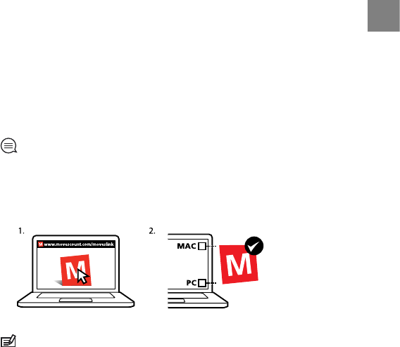
this documentation can be downloaded at www.suunto.com.
19.6 Patent notice
This product is protected by pending patent applications and their
corresponding national rights: US 11/169,712, US 12/145,766, US 61/649,617,
US 61/649,632, FI20116231, USD 603,521, EP 11008080, EU designs
001296636-0001/0006, 001332985-0001 or 001332985-0002 USD 29/313,029,
USD 667,127, (HR belt: US 7,526,840, US 11/808,391, US 13/071,624, US
61/443,731). Additional patent applications have been filed.
19.7 Warranty
SUUNTO LIMITED WARRANTY
Suunto warrants that during the Warranty Period Suunto or a Suunto Authorized
Service Center (hereinafter Service Center) will, at its sole discretion, remedy
defects in materials or workmanship free of charge either by a) repairing, or b)
replacing, or c) refunding, subject to the terms and conditions of this Limited
Warranty. This Limited Warranty is only valid and enforceable in the country
of purchase, unless local law stipulates otherwise.
132
Warranty Period
The Limited Warranty Period starts at the date of original retail purchase. The
Warranty Period is two (2) years for display devices. The Warranty Period is one
(1) year for accessories including but not limited to PODs and heart rate
transmitters, as well as for all consumable parts.
The capacity of rechargeable batteries decreases over time. In case of abnormal
capacity decrease due to defective battery, Suunto warranty covers the battery
replacement for 1 year or for at maximum 300 charging times, whichever comes
first.
Exclusions and Limitations
This Limited Warranty does not cover:
1. a) normal wear and tear, b) defects caused by rough handling, or c) defects
or damage caused by misuse contrary to intended or recommended use;
2. user manuals or any third-party items;
3. defects or alleged defects caused by the use with any product, accessory,
software and/or service not manufactured or supplied by Suunto;
This Limited Warranty is not enforceable if item:
1. has been opened beyond intended use;
2. has been repaired using unauthorized spare parts; modified or repaired by
unauthorized Service Center;
3. serial number has been removed, altered or made illegible in any way, as
determined at the sole discretion of Suunto;
4. has been exposed to chemicals including but not limited to mosquito
repellents.
133
en
Suunto does not warrant that the operation of the Product will be uninterrupted
or error free, or that the Product will work with any hardware or software
provided by a third party.
Access to Suunto warranty service
You must have proof of purchase to access Suunto warranty service. For
instructions how to obtain warranty service, visit www.suunto.com/support.
If you have questions or doubts, a comprehensive range of support materials
is available there, or you can post a question directly to Suunto Contact Center.
Alternatively, you may contact Suunto Contact Center at the phone number
listed on the last page of this document. Suuntos qualified customer support
staff will help you and, if needed, troubleshoot your product during the call.
Limitation of Liability
To the maximum extent permitted by applicable mandatory laws, this Limited
Warranty is your sole and exclusive remedy and is in lieu of all other warranties,
expressed or implied. Suunto shall not be liable for special, incidental, punitive
or consequential damages, including but not limited to loss of anticipated
benefits, loss of data, loss of use, cost of capital, cost of any substitute
equipment or facilities, claims of third parties, damage to property resulting
from the purchase or use of the item or arising from breach of the warranty,
breach of contract, negligence, strict tort, or any legal or equitable theory, even
if Suunto knew of the likelihood of such damages. Suunto shall not be liable
for delay in rendering warranty service.
134
Index
A
adjusting display contrast, 20
after exercise, 90, 92
alarm, 25
Alti & Baro mode, 51
Altimeter profile, 56
Automatic profile, 59
Barometer profile, 57
correct readings, 52
incorrect readings, 53
profiles, 54
recording altitude, 79
reference value, 5455
altitude
recording, 79
setting altitude manually, 82
altitude reference value, 55
autopause, 88
autoscroll, 17
B
backlight, 12
battery
charging, 126
HR belt, 128
button lock, 12
buttons, 11
C
calibrating
compass, 63
Foot POD Mini, 115
Suunto Bike POD, 115
charging the battery, 14
compass, 63
calibrating, 63
declination value, 65
during exercise, 82
customizing, 15
custom sport modes, 17
D
display contrast, 20
dual time, 24
during exercise, 78
compass, 82
navigating, 85
135
dynamic summary, 92
F
finding back, 86
FusedAlti, 55, 79
enabling, 60
measuring altitude, 60
FusedSpeed, 103
G
GPS, 28
resetting, 111
troubleshooting, 29
GPS accuracy, 31
GPS timekeeping, 26
grids, 29
H
heart rate belt, 7374
pairing, 112
I
icons, 119
interval timer, 83
inverting display, 19
L
language, 111
laps, 78
location, 31
logbook, 90
M
maintenance, 125
measuring altitude
FusedAlti, 60
memory left indicator, 91
Movescount
connecting to, 15
Suunto App, 19
Suunto App Designer, 19
Suunto App Zone, 19
multisport training, 93
preconfigured multisport mode,
95
N
navigating
during exercise, 85
finding back, 86
point of interest (POI), 38
route, 44
troubleshooting, 29
P
pairing
136
heart rate belt, 112
POD, 112
POD
pairing, 112
POI icons, 120
point of interest (POI)
adding coordinates manually, 35
adding current location, 32
deleting, 41
navigating, 38
position formats, 29
power POD, 116
R
recording altitude, 79
recording tracks, 78
recovery time, 93
resetting GPS, 111
route
adding, 43
deleting, 50
navigating, 44
S
sea level pressure value, 55
service menu, 110
settings, 106
alarm, 25
date, 23
dual time, 24
GPS timekeeping, 26
time, 2223
sleep mode, 111
slope, 116
sport mode
after exercise, 90, 92
during exercise, 78
starting exercise, 76
sport modes, 17, 71
additional options, 72
starting exercise, 76
stopwatch, 68
activating, 67
deactivating, 67
laps, 68
pausing, 68
resetting, 68
sunrise and sunset, 51
Suunto App, 19
Suunto App Designer, 19
Suunto App Zone, 19
Suunto Foot POD, 115
swimming, 96
drills, 102
indoor swimming, 96
outdoor swimming, 98
137
teaching swimming styles, 99
T
time mode, 22
timers
stopwatch, 68
time settings, 22
GPS timekeeping, 26
Track back, 87
troubleshooting
heart rate signal, 74
U
updating software, 16
W
waypoints, 4344
138
© Suunto Oy 08/2013
Suunto is a registered trademark of Suunto Oy.
All Rights reserved.
SUUNTO CUSTOMER SUPPORT
1. www.suunto.com/support
www.suunto.com/mysuunto
2. support@suunto.com
3. AUSTRALIA +61 1800 240 498
AUSTRIA +43 720 883 104
CANADA +1 800 267 7506
FINLAND +358 9 4245 0127
FRANCE +33 4 81 68 09 26
GERMANY +49 89 3803 8778
ITALY +39 02 9475 1965
JAPAN +81 3 4520 9417
NETHERLANDS +31 1 0713 7269
NEW ZEALAND +64 9887 5223
RUSSIA +7 499 918 7148
SPAIN +34 91 11 43 175
SWEDEN +46 8 5250 0730
SWITZERLAND +41 44 580 9988
UK +44 20 3608 0534
USA +1 855 258 0900
3

Hulp nodig? Stel uw vraag in het forum

Spelregels

Misbruik melden

Gebruikershandleiding.com neemt misbruik van zijn services uitermate serieus. U kunt hieronder aangeven waarom deze vraag ongepast is. Wij controleren de vraag en zonodig wordt deze verwijderd.

Product:

Bijvoorbeeld antisemitische inhoud, racistische inhoud, of materiaal dat gewelddadige fysieke handelingen tot gevolg kan hebben.

Bijvoorbeeld een creditcardnummer, een persoonlijk identificatienummer, of een geheim adres. E-mailadressen en volledige namen worden niet als privégegevens beschouwd.

Spelregels forum

Om tot zinvolle vragen te komen hanteren wij de volgende spelregels:

Belangrijk! Als er een antwoord wordt gegeven op uw vraag, dan is het voor de gever van het antwoord nuttig om te weten als u er wel (of niet) mee geholpen bent! Wij vragen u dus ook te reageren op een antwoord.

Belangrijk! Antwoorden worden ook per e-mail naar abonnees gestuurd. Laat uw emailadres achter op deze site, zodat u op de hoogte blijft. U krijgt dan ook andere vragen en antwoorden te zien.

Abonneren

Abonneer u voor het ontvangen van emails voor uw Suunto AMBIT2 1.5 bij:


U ontvangt een email met instructies om u voor één of beide opties in te schrijven.


Ontvang uw handleiding per email

Vul uw emailadres in en ontvang de handleiding van Suunto AMBIT2 1.5 in de taal/talen: Engels als bijlage per email.

De handleiding is 1,97 mb groot.


U ontvangt de handleiding per email binnen enkele minuten. Als u geen email heeft ontvangen, dan heeft u waarschijnlijk een verkeerd emailadres ingevuld of is uw mailbox te vol. Daarnaast kan het zijn dat uw internetprovider een maximum heeft aan de grootte per email. Omdat hier een handleiding wordt meegestuurd, kan het voorkomen dat de email groter is dan toegestaan bij uw provider.

Stel vragen via chat aan uw handleiding

Stel uw vraag over deze PDF

Andere handleiding(en) van Suunto AMBIT2 1.5

Suunto AMBIT2 1.5 Gebruiksaanwijzing - Nederlands - 147 pagina's

Suunto AMBIT2 1.5 Gebruiksaanwijzing - Deutsch - 155 pagina's

Suunto AMBIT2 1.5 Gebruiksaanwijzing - Espanõl - 149 pagina's


Uw handleiding is per email verstuurd. Controleer uw email

Als u niet binnen een kwartier uw email met handleiding ontvangen heeft, kan het zijn dat u een verkeerd emailadres heeft ingevuld of dat uw emailprovider een maximum grootte per email heeft ingesteld die kleiner is dan de grootte van de handleiding.

Er is een email naar u verstuurd om uw inschrijving definitief te maken.

Controleer uw email en volg de aanwijzingen op om uw inschrijving definitief te maken

U heeft geen emailadres opgegeven

Als u de handleiding per email wilt ontvangen, vul dan een geldig emailadres in.

Uw vraag is op deze pagina toegevoegd

Wilt u een email ontvangen bij een antwoord en/of nieuwe vragen? Vul dan hier uw emailadres in.


Info