579698
12
Verklein
Vergroot
Pagina terug
1/58
Pagina verder
User Manual
Software
for personal
trackers
MyTrack
SOFTWARE FOR PERSONAL TRACKING
User Manual
September Edition 2009
Limitation of Liability
The Manufacturer reserves the right to modify the software or the software specifi cations in this manual without previous
warning. Any copy of this manual, in part or in full, whether by photocopy or by other means, even of electronic nature,
without the manufacture giving written authorisation, breaches the terms of copyright and is liable to prosecution.
It is absolutely forbidden to use the software for different uses other than those for which it has been devised for, as
inferred to in this manual. When using the features in this software, obey all laws and respect privacy and legitimate rights
of others.
EXCEPT TO THE EXTENT PROHIBITED BY APPLICABLE LAW, UNDER NO CIRCUMSTANCES SHALL THE
MANUFACTURER BE LIABLE FOR CONSEQUENTIAL DAMAGES SUSTAINED IN CONNECTION WITH SAID PRODUCT
AND THE MANUFACTURER NEITHER ASSUMES NOR AUTHORIZES ANY REPRESENTATIVE OR OTHER PERSON TO
ASSUME FOR IT ANY OBBLIGATION OR LIABILTY OTHER THAN SUCH AS IS EXPRESSLY SET FORTH HEREIN.
All trademarks in this manual are property of their respective owners.
Microsoft Windows 2000, XP, Vista, AutoRoute are trademarks or registered trademarks belonging to Microsoft Corporation
in the United States and /or other countries.
Google and Google Earth are trademarks or registered trademarks belonging to Google Inc.
MapQuest is a registered trademark belonging to MapQuest Inc.
ROUTE 66 is a registered trademark belonging to ROUTE 66.
Bluetooth is a registered trademark of Bluetooth SIG, Inc.
The information contained in this manual is for information purposes only, is subject to changes without previous warning
and cannot be considered binding for the Manufacturer. The Manufacturer assumes no responsabilty for any errors or
incoherence possibly contained in this manual.
Printed in Italy.
Contents
Introduction
Introduction
...........................................................................................................................
...........................................................................................................................
5
Installation
Installation
.............................................................................................................................
.............................................................................................................................
6
Getting Started
Getting Started
......................................................................................................................
......................................................................................................................
8
Software Confi guration .................................................................................................. 8
Tracker Confi guration..................................................................................................... 8
Connection between the Tracker and MyTrack
...................................................................
...................................................................
10
Local Connection using the USB Port ......................................................................... 10
Remote Connection using a PSTN/GSM Modem ........................................................ 11
Remote Connection in GPRS Network ......................................................................... 11
How to Display the Position of the Tracker
..........................................................................
..........................................................................
14
Georeference ............................................................................................................... 14
VirtualEarth and GoogleMaps...................................................................................... 15
Navigator Software (option) ......................................................................................... 16
Connection with other Map Software ........................................................................... 16
How to Display the Position using Coordinates ........................................................... 17
Updates
Updates
..............................................................................................................................
..............................................................................................................................
18
Updating the Firmware Version of the Tracker............................................................. 18
Updating of MyTrack.................................................................................................... 19
MyTrack Software Structure
................................................................................................
................................................................................................
20
Map .............................................................................................................................. 21
Pop-Up Windows ......................................................................................................... 21
Tracker Info........................................................................................................... 22
Tracking ................................................................................................................ 22
Data Download ..................................................................................................... 23
Tracker Phone Book ............................................................................................. 24
Search POI (Point Of Interest) .............................................................................. 25
Routing ................................................................................................................. 25
Toolbar ......................................................................................................................... 27
Status Bar .................................................................................................................... 29
Drop Down Menu ......................................................................................................... 30
File ........................................................................................................................ 30
OPEN ............................................................................................................... 31
PAGE SETUP...................................................................................................... 32
PRINT PREVIEW .................................................................................................. 33
PRINT ............................................................................................................... 34
View ...................................................................................................................... 35
Tools ..................................................................................................................... 36
A
DDRESS BOOK ................................................................................................. 37
SETTINGS .......................................................................................................... 38
GEOREFERENCE .................................................................................................. 42
Remote Unit .......................................................................................................... 44
USB CONNECT ................................................................................................. 44
CONNECT COM PROFILE .................................................................................... 45
DISCONNECT ..................................................................................................... 45
SETUP .............................................................................................................. 45
INFO ................................................................................................................ 53
Help ...................................................................................................................... 55
Introduction
5
Introduction
MyTrack is a software, included with the trackers, which allows to manage the several functions directly by
PC.
The main software features are:
direct connection with the tracker using the USB port or, at a distance, by modem or GPRS network
map management
management of data stored in the tracker
tracker setup
MyTrack can be used in IBM compatible PC in Microsoft Windows 2000, XP or Vista environment.
Before using MyTrack, the entire installation procedure must be performed.
6
Installation
Installation
Minimum confi guration of the PC:
IBM compatible PC with Pentium IV processor
Microsoft Windows
®
2000, XP or Vista operating system
minimum of 300MB of available memory on the hard disk
SVGA graphic card
CD ROM or DVD drive
USB communication port
modem
keyboard and mouse
Other recommended equipment:
GSM modem for remote connection
scanner for scanning of local maps and successive georeferencing
internet connection
printer
To install My Track on the hard disk, follow these instructions:
Turn on the PC and wait until the Microsoft Windows1.
®
environment has been loaded.
Insert the included CD in the CD-ROM drive of the PC.2.
The installation begins automatically. If installation does not occur automatically, manually run the “setup.3.
exe” fi le contained in the principal folder of the CD-ROM.
To start the program, double-click on the MyTrack icon found on the desktop.4.
During the installation, under the principal folder of the hard disk, a MyTrack Data fi le is created which contains
the sub-folders EventLog, GPSLog, MapRaster, MapShape, Tracking.
7
Installation
The data recorded or downloaded by MyTrack is automatically saved in the sub-folders:
EventLog : contains the recorded data relevant to the events detected by the tracker.
GPSLog : contains the GPS data recorded by the tracker and following downloaded.
MapRaster : contains maps which have been georeferenced.
MapShape : contains digital maps in Shape Files format.
Tracking : contains the GPS data recorded by the software after the tracker connection.
8
Getting Started
Getting Started
Software Confi guration
After MyTrack installation and start-up, control and change the software confi guration according to the
needs.
The main settings to carry out for the MyTrack confi guration are:
type of language for displayed messages (refer to the chapter MyTrack Software Structure, paragraph
Drop Down Menu)
type of maps to display the tracker in real time or in the recorded tracking (refer to the chapter How to
Display the Position of the Tracker)
communication profi les setup (refer to the chapter Connection between the Tracker and MyTrack,
paragraph Remote Connection using PSTN/GSM Modem)
contacts setup in the list of devices (refer to the chapter Connection between the Tracker and MyTrack,
paragraph Remote Connection using PSTN/GSM Modem)
enabling of the GPS data communication in NMEA format (refer to the chapter Connection between the
tracker and MyTrack, paragraph Connection with other Map Software)
time zones (refer to the chapter MyTrack Software Structure, paragraph Drop Down Menu)
position format (refer to the chapter MyTrack Software Structure, paragraph Drop Down Menu)
Tracker Confi guration
The tracker comes with a default confi guration which can be changed to suit individual requirements. To
confi gure the tracker, run MyTrack and connect the tracker using the USB port (refer to the chapter Connection
between the Tracker and MyTrack, paragraph Connection using the USB Port).
9
Getting Started
To customize the following main settings, refer to the chapter MyTrack Software Structure:
name or ID
date and time
level of the motion sensor sensitivity
maximum waiting time required to establish the end of tracker motion
GPRS network connection parameters
power save mode
info SMS parameters
cyclic position SMS function
anchor function
geofence function
nder function
guide function
GPS data recording parameters
phone numbers to send SOS messages
tracker phone book
NOTE: The listed parameters can be unavailable according to the connected tracker model.
NOTE: It is advisable to input at least name, date and hour, and the time-zone of the device.
10
Connection between the Tracker and MyTrack
The model of the tracker is automatically recognized.
Connection can be done in three different ways:
local connection, using the PC USB port
remote connection, using a PSTN/GSM modem
remote connection through GPRS network
NOTE: A mobile phone can be used also as a GSM modem. In this case, to connect it with the
PC, use the proper serial or USB cable or connect the mobile phone using Bluetooth™.
Connection with MyTrack allows several operations, such as:
real time reading of tracker GPS data
easy setup of tracker parameters
download of the recording done by the tracker
update of the tracker fi rmware version
Local Connection using the USB Port
To connect a tracker using the PC USB port, proceed as follows:
Connect the tracker to the PC USB port using the proper included cable.1.
To connect the tracker, press the 2.
p
key and select USB.
A green LED will appear on the status bar, at the bottom of the main window.3.
11
Connection between the Tracker and MyTrack
Remote Connection using a PSTN/GSM Modem
To connect in remote mode a tracker using a PSTN/GSM modem, proceed as follows:
Select 1. Settings from the Tools menu (refer to the chapter MyTrack Software Structure, paragraph Drop
Down Menu).
Select the 2. Communication tab.
In the 3. Profi le eld, add a new communication profi le selecting Modem or GSM Modem as profi le type.
In the 4. Com Port eld, select the COM port where the PSTN/GSM modem is connected and set the
communication speed to 9600 bps.
Perform the setup in the 5. Modem eld.
After having set these three fi elds, confi rm the values with the 6. OK key.
Access the MyTrack 7. Address Book and add a new device using the COM profi le previously set. Check if
it is set as default.
Confi rm the inserted data with the 8. Close key.
To connect the tracker, press the 9.
key and select COM Profi le.
A green LED will appear on the status bar, at the bottom of the main window.10.
NOTE: Be sure that the modem is switched ON and connected to the PC. In case of a PSTN
modem, check if it is also connected to the phone line.
NOTE: After modem installation procedure, it is advisable to restart the PC.
Remote Connection in GPRS Network
To connect the tracker using GPRS network, proceed as follows:
Connect the tracker by USB or modem (refer to the previous paragraphs).1.
Select 2. Setup from the Remote Unit menu.
In the setup window, set the GPRS communication parameters (refer to the chapter 3. MyTrack Software
Structure, paragraph Drop Down Menu).
12
Connection between the Tracker and MyTrack
Confi rm the values with 4. Apply key and close the window with Close key.
Select 5. Settings from the Tools menu.
The software setup window will appear. Select the 6. Communication tab.
In the 7. GPRS eld, enable the function and set the Input Port and Local IP eld.
Confi rm the values with the 8. OK key.
The GPRS communication can be enabled:
automatically, if a rate for GPRS connection has been set.
manually, sending an SMS command (wgprs) to the tracker by means of a GSM device (e.g. a mobile
phone).
For the manual connection, MyTrack can accept the connection automatically if the Autoanswer fi eld in the
GPRS communication setup was enabled, if not, MyTrack will display a confi rmation message to open the
communication channel.
For the automatic cyclic connection, MyTrack will accept and close automatically the connection
Examples of GPRS communication setup relevant to the used network provider:
Network provider AP Name AP IP User Name Password
TIM ibox.tim.it empty empty empty
VODAFONE web.omnitel.it empty empty empty
WIND (prepaid) internet.wind empty empty empty
WIND (with subscription) internet.wind.biz empty empty empty
13
Connection between the Tracker and MyTrack
To communicate with the tracker by PC in GPRS network, check if there is any fi rewall and, if necessary, allow
to access the port intended to be used for communication. It is advisable to perform this operation only if you
are technically qualifi ed to do so.
If Windows Firewall is enabled, during the communication GPRS access, the following window is displayed.
Keep Blocking Block access to the port and therefore do
not consent GPRS communication.
Unblock Permanently unblock access to the port
and allow the GPRS communication.
Ask Me Later Temporarily unblock access to the
port and allow temporary GPRS
communication. On the next attempt at
GPRS communication, the same warning
window will appear.
In case of external fi rewall in use, refer to the network administrator.
14
How to Display the Position of the Tracker
The position of the tracker can be displayed, in real time, on a map. There are different methods to identify
this position:
by scanning a map and following georeference.
by VirtualEarth or GoogleMaps (if internet connection is available).
by Navigator map software (option).
by connection with other map software (i.e. AutoRoute™, ROUTE 66
®
, …).
by the coordinates (latitude, longitude) of the tracker, inserted in the appropriate web sites (e.g.
MapQuest
®
).
Georeference
This function allows to assign the correct coordinates to a map, after having it digitalized.
Furthermore, it gives the possibility to use local maps, more detailed or specialized, for specifi c use.
The two operations to perform are:
scan the image or the photo of a map to obtain a digital format
set three reference points on the digital image
As for the Navigator maps (optional), an internet connection is not required.
To perform georeferencing, proceed as follows:
Scan the image or photo of a map and save it on the PC in .TIFF, .GIF, .BMP, or .JPG format.1.
Select 2. Georeference from the Tools menu.
The Georeference window will be displayed (refer to the chapter 3. MyTrack Software Structure, paragraph
Drop Down Menu).
Load the previously digitalized image.4.
Select a reference point, left-clicking the mouse on the displayed image.5.
After selecting the fi rst reference point, the corresponding coordinates will be highlighted.6.
15
How to Display the Position of the Tracker
In the highlighted fi elds, manually set the coordinates of the point of reference selected on the map.7.
Repeat points 5, 6 and 7 to set the other two reference points.8.
After the three reference points setup, georeference the image with the 9. Georeference key.
If the Shapemap mode is in use, all the georeferenced images are listed in the Layers eld on the Software
Setup window (refer to the chapter MyTrack Software Structure, paragraph Drop Down Menu).
NOTE: It is suggested to set as reference points areas easily identifi ed (road crossings, …) or
well-known places. It is better to selected points near the external edges of the map to obtain
suffi cient accuracy.
NOTE: Use the shortcut Ctrl+G everytime the degree symbol (°) must be inserted in the
coordinates fi elds.
The tracker position accuracy, in the georeferenced image, depends on:
accuracy of the scanner image.
position of the three reference points set on the image: the closer are the three points to the edges of the
image, the higher is the accuracy (level).
accuracy with which the coordinates of the three reference points are set on the actual map.
VirtualEarth and GoogleMaps
It is possible to display the position of the tracker on VirtualEarth maps or GoogleMaps.
For this function, a fast internet connection (e.g. ADSL) is necessary.
To choose the type of map to display, proceed as follows:
Select Settings from the Tools menu (refer to the chapter 1. MyTrack Software Structure, paragraph Drop
Down Menu).
The 2. Software Setup window will appear. Select the Map Tracking tab.
In the 3. Maps eld, select VirtualEarth or GoogleMaps.
The selected map type will be displayed on the window.4.
16
How to Display the Position of the Tracker
Navigator Software (option)
The maps integrated by the Navigator software allow to display fast and easy the tracker on the map, without
need of an internet connection or to perform virtual connecting procedures. Furthermore, other included functions
(Search POI, Routing) are particularly useful in many occasions.
This map software allows to display detailed maps of the following countries:
Andorra, Austria, Belgium, Denmark, Finland, France, Germany, Great Britain, Ireland, Italy, Lichtenstein,
Luxemburg, Monaco, Netherlands, Norway, Poland, Portugal, Czech Republic, San Marino, Spain,
Sweden, Switzerland, Vatican.
The maps of each country can be enabled or disabled. For best process speed, the enabling of only the
interested countries is recommended.
To display the Navigator software maps, proceed as follows:
Select 1. Settings from the Tools menu (refer to the chapter MyTrack Software Structure, paragraph Drop
Down Menu).
Select 2. Map Tracking tab.
In the 3. Maps eld, select Navigator and confi rm with OK key.
To enable or disable the countries included in the maps, repeat points 2 and 3.4.
In the 5. Countries eld, enable or disable the countries by left-clicking the mouse.
Confi rm with 6. OK key.
To display further information about this map software, refer to the assistance (Help) provided by the Navigator
software.
Connection with other Map Software
It is possible to display the position of the tracker by virtual connection with other map software (i.e.
AutoRoute™, ROUTE 66
®
, ...).
17
How to Display the Position of the Tracker
To display the position of the tracker on another map software, proceed as follows:
In MyTrack, select 1. Settings from theTools menu (refer to the chapter MyTrack Software Structure, paragraph
Drop Down Menu).
Select the 2. Map Tracking tab.
In the 3. NMEA Output eld, enable the function, select the virtual port’s communication speed (set the same
speed for the map software intended for use) and confi rm with the OK key.
Run the map software (i.e. AutoRoute™, ROUTE 664.
®
, ...).
To display in real time the device position connect the tracker in remote or local mode, otherwise to review 5.
a GPS data recording of the device open the desired fi le and press the
key.
On the programming window of the map software, set the communication parameters for incoming GPS 6.
data, being careful to select the same virtual port indicated by MyTrack (refer to the user’s manual of the
chosen software).
If all settings have been carried out properly and the map software receives GPS data, the tracker position 7.
is displayed on the map of the additional software.
How to Display the Position using Coordinates
Through map or navigation web sites (i.e. MapQuest
®
), it is possible to locate the tracker position simply by
using the latitude and longitude data contained in the SMS message received continuously or on request. An
internet connection is necessary for this function.
To represent the coordinates on a map, perform the following procedure:
Run the internet browser.1.
Access the desired navigation web site (i.e. www.mapquest.com).2.
Insert the latitude and longitude coordinates in the relevant fi elds.3.
Confi rm the values.4.
The position of the tracker will be indicated on a map.5.
18
Updates
Updates
Updating the Firmware Version of the Tracker
This function allows to update the fi rmware version of the tracker.
WARNING: If the tracker to be updated is connected in GSM/GPRS network, be sure that the
GSM/GPRS network signal level is high.
WARNING: If the tracker to be updated is connected by a USB cable, do not remove the cable
during the update.
WARNING: Be sure that the tracker battery is fully charged.
WARNING: If the tracker has the same fi rmware version of the update fi le, the upgrading is
stopped and an information message is displayed.
To update the tracker, perform the following procedure:
Connect the tracker to be updated (refer to the paragraph 1. Connection between the Tracker and
MyTrack).
Display the tracker information window and press the 2. Upgrade key (refer to the chapter MyTrack Software
Structure, paragraph Drop Down Menu).
The tracker fi rmware updating bar is displayed.3.
Press the 4. Update key to access the update fi le.
Select the update fi le and press the 5. Open key.
When the fi le is opened, the update of the tracker is done automatically.6.
19
Updates
Wait until the update is completed, when the tracker is turned off automatically. If the device is connected 7.
to USB port, disconnect it at the end of the update.
Updating of MyTrack
If an internet connection is available, the updates are automatically downloaded every time MyTrack is run.
To check if a MyTrack upgrade is available when the software is running, select Check for Upgrade in the Help
menu (function available only in case of internet connection; for further details, refer to the chapter MyTrack
Software Structure, paragraph Help).
20
MyTrack Software Structure
The main window of MyTrack displays:
a map in the right-hand panel
pop-up windows in the left panel
toolbar
drop down menu
21
MyTrack Software Structure
NOTE: The displayed windows, shown in the following paragraphs of the manual, depend on
the installed maps type and the connected tracker model.
Map
The right-hand area displays the selected map. When MyTrack is run for the fi rst time, the Shapemap is
displayed. The Shapemap is a superfi cial map of the world in Shape Files format, on which the georeferenced
maps can be displayed.
To select the type of map, refer to the paragraph Drop Down Menu.
The maps which can be selected are:
Navigator (option)
Shapemap
VirtualEarth
GoogleMaps
Pop-Up Windows
The left-hand area contains 6 pop-up windows which allow to display:
Tracker Info : general tracker information.
Tracking : information about the position of the tracker.
Data Download : allows the memory data downloading of the connected tracker.
Tracker Phone Book : allows the phone book setup of the connected tracker.
Search POI : searches for places, pre-established areas (i.e. Airport) on the map.
Routing : searches for the shortest (or the fastest, ...) route between the starting and the arrival point.
22
MyTrack Software Structure
Some functions (such as Search POI, Routing) are included only if the Navigator maps are integrated and,
even if not directly connected to the use of GPS, can be useful in many occasions.
To display a pop-up window, click on the box . To hide a pop-up window, click on the box .
Tracker Info
Allows to display general information relevant to the connected tracker.
Tracker ID ID of the tracker.
Battery Level Battery level of the tracker.
Motion Motion status of the tracker.
GPRS GPRS network availability.
Tracking
Allows to display the information relevant to the position of the tracker, in real time or during a recording in
process.
Latitude Latitude expressed in the pre-set format.
Longitude Longitude expressed in the pre-set format.
Altitude [m] Altitude in meters above sea level.
Speed [km/h] Speed in Km/h.
Direction [°] Direction in degrees with reference to the North.
FIX Expresses the reception quality of the GPS signal, valid or
not valid.
Satellites Satellites number visible by the tracker.
Date & Time Date and hour of the connected tracker or of the recording
in process.
Point Actual and total number of position points read from the
tracker.
23
MyTrack Software Structure
Address Info Indicates the location of the tracker. If the tracker is not on
a road which is usable and identifi able by an address, this
eld remains empty. This fi eld is available only for Navigator
maps.
Data Download
Allows the transfer of data recorded by the connected tracker.
Event LOG Select the event LOG recordings to be downloaded or
deleted.
GPS Records Select the GPS data recordings to be downloaded or
deleted.
Erase key Erases the selected recording data.
Download key Downloads the selected recording data. A new window is
displayed for tracking selection of the fi le to be saved.
During downloading or erasing process, a progress bar and the remaining time are displayed.
24
MyTrack Software Structure
Tracker Phone Book
Allows to set the phone book of the connected tracker. This window is displayed only when the LCD version
tracker is connected to MyTrack.
Name Allows to set the contact name (max. 9 characters).
Phone number Allows to set the contact’s phone number.
Write key Saves the set contacts in the tracker.
During the contacts saving in the phone book, a progress bar is displayed.
25
MyTrack Software Structure
Search POI (Point Of Interest)
Allows to search for places, pre-established areas on the currently displayed map.
This window is displayed only if the Navigator maps are installed and selected (optional).
Search POI Selects a category.
Map View Allows to search for the point of interest on the entire area of
the currently displayed map.
Nearest Allows to search for the point of interest in the areas around
a point.
Latitude Sets the latitude of the point (Nearest function).
Longitude Sets the longitude of the point (Nearest function).
Search key Searches for the point of interest according to the setup.
Map key Allows to set the point of interest (Nearest function) clicking
directly on the map.
Routing
Allows to search the shortest route (or the fastest, ...) between the departure and the arrival point.
This window is displayed only if the Navigator maps are installed and selected (optional).
Route Start
Latitude Sets the latitude for the departure point.
Longitude Sets the longitude for the departure point.
START key Allows to set the departure point clicking directly on the
map.
Route End
Latitude Sets the latitude for the arrival point.
Longitude Sets the longitude for the arrival point.
STOP key Allows to set the arrival point clicking directly on the
map.
26
MyTrack Software Structure
Search Selects the type of route; available choices: shortest, fastest, cheapest.
Search key Searches for the route according to the setup.
After carrying out a search, the route to follow is evidenced in red on the map.
Furthermore, a table appears below containing all information regarding the route:
Number of the recommended road
Name of the recommended road
Type of recommended road
Length of the recommended road (in meters)
Time required for the chosen road (in seconds)
The search for other itineraries without losing the data from the previous search is possible. Every search is
sub-divided in the table under the map using different tabs.
27
MyTrack Software Structure
Toolbar
The menus and the keys of MyTrack are described below. Some keys correspond to items contained in the
drop down menus, for this reason, some functions can be chosen both from the menus or by pressing the
relevant key.
NOTE: Some toolbar keys are shown only if the relevant function is enabled (i.e. keys relevant
to the recording).
NOTE: The displayed windows, shown in the following paragraphs of the manual, depend on
the connected tracker model.
Short cut Key Function
Ctrl+O
Opens a data fi le recorded by the device or saved by MyTrack.
F7
Accesses the MyTrack setup.
Ctrl+B
Displays the MyTrack Address Book containing the list of the trackers to
be connected.
Alt+P
Print the current fi le in graphic or table mode according to the selected
print mode.
Access the print page settings.
28
MyTrack Software Structure
F9 Connects the device according to the selected mode.
F10
Disconnects the device.
F8
Settings of the connected device.
Ctrl+I
Displays the information on the connected device and allows access to
the fi rmware updating procedure.
Zoom-out function.
Zoom bar.
Zoom-in function.
Zoom function (available only in Shapemap display mode).
Pan function (available only in Shapemap display mode).
Ctrl+F
Centers the position of the device on the map.
Ctrl+P
Centers the position of the device on the map every time the margin of the
map is reached.
F1
Provides assistance for the application (on-line help).
Plays the recording of a tracking done by the device.
Puts the recording in pause.
Interrupts the recording playing.
Returns to the beginning of the recording.
29
MyTrack Software Structure
Pressed once: rewinds the recording one point.
Pressed until 5 sec.: rewinds the recording slowly.
Pressed more than 5 sec.: rewinds the recording quickly.
Pressed once: forwards the recording one point.
Pressed until 5 sec.: forwards the recording slowly.
Pressed more than 5 sec.: forwards the recording quickly.
Brings the recording to the end.
Bar for the recording scroll.
Increases the recording speed.
Reduces the recording speed.
Adjusts the recording speed.
Status Bar
The status bar is displayed at the bottom of the main window.
The right area of the status bar shows the connection status:
Green LED=connection OK
Red LED=no connection
The name of the data fi le in use is displayed on the left of the connection status.
The left area of the statusbar shows the information relevant to the software operation, to the modem connection
in real time, and the enabled status of GPRS autoanswer by “G”.
30
MyTrack Software Structure
Drop Down Menu
The MyTrack functions can be accessed by selecting the items in the drop down menus. The following
description shows the functions contained in each menu (File, View, Tools, Remote Unit, Help).
File
The File menu allows to carry out the general functions relevant to a fi le.
Open Allows to open a fi le containing position data recorded by the tracker or
a fi le containing an event LOG. It is possible to display this data on the
map.
Close Allows to close the fi le in use.
Page Setup Allows to set the page to print.
Print Preview Allows to display the print preview of the current fi le in graphic or table
mode according to the selected print mode.
31
MyTrack Software Structure
Print Allows to print the track in graphic or table mode according to the
selected print mode.
Exit Exits from MyTrack.
OPEN
In MyTrack, the following fi les can be opened:
GPS Log fi les (*.gsl)
Event Log fi les (*.evl)
A GPS Log fi le contains all position data recorded by the device or archived by MyTrack. At fi le opening, a
table containing all tracking data will be displayed and the tracking starting point will be shown on the map.
In the table, selecting the row of a tracking point, it will be shown on the map automatically.
Pressing
key, the recorded tracking will be played and in the table will be highlighted the row corresponding
to the point showed on the map in real time.
The recording review is not stopped in the event that GEOPOINT carries out an automatic connection to
MyTrack during the review of the recorded tracking. If the recording stops or is stopped manually, MyTrack
will display the connected GEOPOINT position in real time.
Up to 10 fi les can be opened simultaneously and the tracking for each fi le can be reviewed. Each opened fi le
is sub-divided in the table using different tabs. It is possible to switch from a fi le to another by selecting the
desired tab. The recording review in progress is automatically stopped in that moment every time another fi le
tab is selected.
An Event Log fi le contains all the events detected and recorded by the device. At fi le opening, a table at the
map bottom will be displayed, containing a description for each event (date, time, event type).
32
MyTrack Software Structure
PAGE SETUP
This function allows to carried out the print page settings.
Paper
Size Allows to select the paper size to
print.
Source Allows to select the paper source.
Orientation
Allows to select the paper orientation. Available choices:
Portrait
Landscape
33
MyTrack Software Structure
Margins (millimeters)
Allows to set the page margins to print (Left, Right, Top,
Bottom).
Printer key Allows to access the printer
settings.
PRINT PREVIEW
This function allows to display the print preview of the track fi le currently used, in graphic or table mode,
according to the selected print mode.
Table Selecting this item, the print preview will be displayed
in table format.
Graphic (map) Selecting this item, the print preview will be displayed
in graphic format.
Printer Settings key Allows to access the printer settings.
Page Settings key Allows to access the page settings.
Print key Display the print preview according to the carried
out settings.
34
MyTrack Software Structure
Table Mode Graphic Mode (map)
PRINT
This function allows to print the fi le currently used, in graphic or table mode, according to the selected print
mode.
Table Selecting this item, print the current fi le in table
format.
Graphic (map) Selecting this item, print the current fi le in graphic
format.
Printer Settings key Allows to access the printer settings.
Page Settings key Allows to access the page settings.
Print key Print the current fi le according to the carried out
settings.
35
MyTrack Software Structure
View
The View menu allows to select the view functions of MyTrack.
Zoom In Zoom in the displayed area.
Zoom Out Zoom out the displayed area.
Center Centers the position of the tracker on the map.
Follow Centers the position of the tracker each time the map edge is reached.
Large Icons Displays the toolbar with larger icons.
36
MyTrack Software Structure
Tools
The Tools menu allows to set the main settings relevant to MyTrack.
Language Selects the software language. Available languages: Italian, English
Address Book Displays the MyTrack Address Book containing the list of the trackers to be
connected.
Settings Allows to set the general settings of MyTrack.
Georeference Allows to georeference a map image.
37
MyTrack Software Structure
ADDRESS BOOK
This function allows to set the tracker parameters to be connected by modem. The arrow, (X) beside a
contact, indicates the default tracker to be connected.
Remote Unit Tracker name preset by the user.
COM Profi le Communication profi le of the tracker (refer to the following paragraph).
Data Number Data number of the SIM card contained in the tracker.
Info Information about the tracker.
key Moves the cursor to the fi rst contact in the Address Book.
key Moves the cursor to the contact preceding the current one.
key Moves the cursor to the contact subsequent to the current one.
key Moves the cursor to the last contact in the Address Book.
key Deletes the selected contact.
Filter eld This fi eld allows to search and display only a few contacts. By typing one or
more letters in the Filter eld, only the contacts having the name which begins
with the same letter will be displayed.
Save&Close key Exits the window saving the set data.
38
MyTrack Software Structure
SETTINGS
This function allows to set general and communication parameters as well as those relevant to the map.
General
General
Language Allows to select the software
language.
Time Correction Allows to select the time zone to
convert the hour (GMT) contained in
the data received by the tracker.
Position Format
Allows to set the displayed position data format for the software
windows. Available choices:
DDD (Degrees, Decimal Degrees)
DM (Degrees, Minutes)
DMS (Degrees, Minutes, Seconds)
Format Example
DDD LAT: 45.123456N - LONG: 9.123456E
DM LAT: 45°12.3456’N - LONG: 9°12.3456’E
DMS LAT: 45°12’34.567”N - LONG: 9°12’34.567”E
Data File Path
... key Allows to change the saving path of data.
WARNING: Restart the PC everytime the saving path is changed.
39
MyTrack Software Structure
Communication
Profi le
Profi le Number of communication profi le.
Type Allows to select the connection type:
by PSTN modem
by GSM modem
Name Name of the communication profi le.
Add key Adds a new communication profi le.
Remove key Removes the profi le with the relevant
displayed number.
Com Port
Port Name Allows to select the COM port where
the modem is connected.
Baud Rate Communication speed (9600bps).
Modem
Init. String Allows to select the modem’s initialization string (default string: ATE0).
Retry Nr. Allows to set the number of automatic attempts to connect the tracker with the
modem.
Timeout Allows to set the maximum waiting time to establish the connection with the tracker;
when time expires, the dialing is stopped.
GPRS
Enable Enables the TCP/IP server for GPRS communication.
Autoanswer Enables the autoanswer on incoming calls via GPRS.
Input Port Allows to set the port number for incoming communication data (9500 default
value).
Local IP Allows to select the IP address of the PC network interface used for internet
connection.
40
MyTrack Software Structure
NOTE: To enable the GPRS connection, ask the network operator if the 9500 entry port can be
used for incoming data communication with TCP protocol. Otherwise, ask another TCP port to
be opened.
NOTE: To check the internet IP address:
press the Start key on the Windows application bar.
select Run function. A window will be displayed.
in the Open eld, type the following command: “cmd /k ipconfi g /all”.
a window will be displayed containing all information relevant to the network interface
installed on the PC.
Map Tracking
Maps
Type Allows to select the map type to
display:
Navigator (optional)
Shapemap
VirtualEarth
GoogleMaps
Units Allows to select the unit system
(meters, miles).
Trace Drawing Selects this function to display the
tracing carried out by the device.
Layers
/ In case of Navigator display mode:
Allows to enable / disable the maps
view of the countries.
In case of Shapemap display mode:
Allows to enable / disable the view of
land morphology and georeferenced
images.
41
MyTrack Software Structure
NMEA Output
Enable Enables communication using the virtual port (refer to the chapter How to Display the
Position of the Tracker, paragraph Connection with other Map Software).
Port Virtual COM port. The virtual COM port shown in this fi eld must be set in the adding
map software for reception of GPS data in NMEA format.
Baud Rate Allows to select the communication speed of the virtual port. The speed value
changes according to the map software used.
NOTE: Before selecting another map, make sure that there is no device connected to MyTrack.
The map selection must be carried out before device connection.
Icons
Available Icons Allows to select the icon type to
display the tracker position.
Selected Icon Shows the selected icon.
42
MyTrack Software Structure
GEOREFERENCE
This function allows to set the georeference parameters of an image. The georeference consists of scanning
an image for following use as a geographic map in MyTrack. Before using the Georeference function, it is
necessary to obtain and scan an image of a map (in *.BMP, *.TIF, *.JPG or *.GIF format). For further details,
refer to the chapter How to Display the Position of the Tracker, paragraph Georeference.
43
MyTrack Software Structure
Point 1
Latitude Allows to set the latitude of point of reference 1.
Longitude Allows to set the longitude of point of reference 1.
Clear key Deletes point of reference 1 on the map and the relevant coordinates.
Point 2
Latitude Allows to set the latitude of point of reference 2.
Longitude Allows to set the longitude of point of reference 2.
Clear key Deletes point of reference 2 on the map and the relevant coordinates.
Point 3
Latitude Allows to set the latitude of point of reference 3.
Longitude Allows to set the longitude of point of reference 3.
Clear key Deletes point of reference 3 on the map and the relevant coordinates.
Clear All key Deletes all reference points and the relevant coordinates.
Load File key Loads the image to be georeferenced.
Georeference key Saves the coordinates of all the three reference points and georeferences the
image.
Close key Closes the window and save the settings.
Zoom Allows to zoom in a particular map displayed.
NOTE: Use the shortcut Ctrl+G everytime the degree symbol (°) must be inserted in the
coordinates fi elds.
44
MyTrack Software Structure
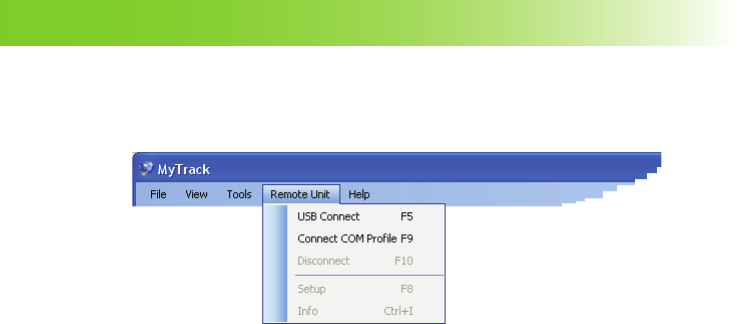
Remote Unit
The Remote Unit menu allows to carry out the main operations relevant to a tracker.
USB Connect Connects the tracker through USB port.
Connect COM Profi le Connects the default tracker in remote mode.
Disconnect Display a confi rming window for device disconnection.
Setup Allows to manage the settings of the connected tracker.
Info Displays the information of the connected tracker and accesses the
rmware upgrading procedure.
USB CONNECT
This function allows to connect the tracker connected by PC USB port. For further details, refer to the chapter
Connection between the Tracker and MyTrack, paragraph Local Connection using the USB Port.
45
MyTrack Software Structure
CONNECT COM PROFILE
This function allows to connect the default contact of the Address Book by modem. Before connecting a
tracker, communication profi le setup and the default contact setup (refer to the chapter Connection between
the Tracker and MyTrack, paragraph Remote Connection using PSTN/GSM Modem) is necessary.
DISCONNECT
This function allows to disconnect the connected device. A confi rming window is displayed.
SETUP
This function allows to manage the settings of the connected tracker. The window is structured in 4 different
tabs (General, SMS, Recordings and SOS, Guide) but each one displays the following keys:
Close key Exits the window without saving.
Apply key Sets in the tracker the settings carried out in this window.
WARNING: All the phone numbers programmable by the Tracker Setup window must be set as
follows: “+” “international dial code” “phone number” (e.g. +393401234567).
46
MyTrack Software Structure
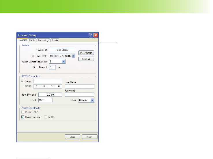
General
General
Tracker ID Allows to assign an ID to the tracker
(i.e. Geo Gloria, ...).
Real Time Clock Displays the date and hour read on
the tracker at window opening. The
displayed format depends on the
operating system installed on the
PC.
PC Synchro key Synchronizes the date and time of
the tracker with that of the PC.
Manual key Set date and time which have been
set manually.
Motion Sensor.. Selects the sensitivity level of the
motion sensor; available range:
disabled, 1(maximum sensitivity)
÷10(minimum sensitivity)
Stop Timeout Selects the maximum waiting time
which is activated when no device
motion is detected; expired this
period, the tracker is considered idle.
Available range: 01÷99 minutes.
Silent Mode Function available only for BOX version. Enable the silent mode. Selecting this
function, the device will emit no sounds, e.g. switching on/off, low battery, etc.
GPRS Connection
AP Name Allows to set the name of the access point. To obtain the relative access point, ask
the GSM network provider.
AP IP Allows to set the access point IP. To obtain the IP of the access point, ask the GSM
network provider.
47
MyTrack Software Structure
Host IP/Name Allows to set the public IP address or name used by the router, modem, ... for internet
access by the PC where MyTrack is in use.
Port Allows to set the GPRS communication port (9500 default value).
User Name Requests this parameter from your network provider.
Password Requests this parameter from your network provider.
Rate Selects the rate in minutes for the automatic tracker connection in GPRS network.
Available choices: Disabled, 1m, 5m, 10m,15m, 30m, 1h, 2h, 4h, 8h, 12h, 18h, 24h.
Power Save Mode
Enabling the Power Save function, the tracker switches ON/OFF automatically, according to the selected
mode. It is very useful as it allows the optimal management of the battery tracker.
Motion Sensor Enables the power save mode according to the device motion.
Position SMS Enables the power save mode according to the cyclic sending of position SMS. This
function can be enabled only if the position SMS function has been previously set
and if the SMS rate value is greater than or equal to 5 minutes.
Cyclic GPRS Enables the power save mode according to the cyclic GPRS connection. This function
can be enabled only if the GPRS connection parameters have been previously set
and if the GPRS connection rate value is greater than or equal to 5 minutes.
NOTE: There are many ways to fi nd one’s own Host IP, for example using internet web-sites (i.e.
myip.it) which read and display the IP value in real time.
48
MyTrack Software Structure
SMS
Alarm SMS
Destination Ph. Nr. Allows to set the phone number
where the device info SMS will be
sent (e.g. +393401234567).
Low Battery Enables / disables the sending of a
message when the battery is low.
GPRS Enables / disables the sending of a
message when the GPRS network is
available or not available.
Motion Enables / disables the sending of
a message when a device motion
is detected or when device motion
stops after a preset time.
Memory Full Enables / disables the sending of a
message when the memory is full.
GPS Enables / disables the sending of a
message when the GPS signal has
been lost or recovered.
Position
Enable Enables the automatic sending of
device position SMS.
Destination Ph. Nr. Allows to set the phone number
where the position SMS will be sent
(e.g. +393401234567).
Rate Allows to set the rate for automatic
position SMS sending.
Geofence & Anchor
Geofence Enables the Geofence function.
Destination Phone Nr. Allows to set the phone number where sending the messages when the device
leaves or re-enters the Geofence area (e.g. +393401234567).
49
MyTrack Software Structure
1st Allows to set manually the latitude and longitude values of the fi rst point of the
area diagonal.
2nd Allows to set manually the latitude and longitude values of the second point of
the area diagonal.
Map key Allows to select the two points of the area diagonal directly on the displayed
map. Left-click on the concerned points with the mouse.
View key Allows to view on the map the set Geofence area (function available only if the
currently used map is GoogleMaps or VirtualEarth).
Anchor Enables the Anchor function.
Destination Phone Nr. Allows to set the phone number where sending the messages when the device
leaves or re-enters the Anchor area (e.g. +393401234567).
Limit Allows to select the radius value of the Anchor area. Available values: 50, 100,
200, 300, 500, 700, 1000, 1500, 2000, 3000, 4000 m.
Finder
SMS Rate Function available only for LCD version. Allows to set the position SMS rate.
Available values: 15s, 30s, 45s, 1min, 2min, 3min, 4min, 5min, 10min, 15min.
In the BOX version the Finder eld is replaced by the display of the SMS language
selection.
SMS Language
SMS Language Function available only for BOX version. Allows to select the language for SMS
messages sent by the device.
50
MyTrack Software Structure
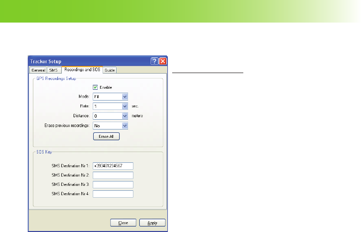
Recordings and SOS
GPS Recordings Setup
Enable Enables the recording.
Mode Allows to select the recording mode.
Choose the most suitable for the
specifi c needs.
RING: after having fi lled all
available memory space, the
previously recorded data is
progressively overwritten with
current data.
FILL: after having fi lled all
available memory space, the
recording stops automatically.
Rate Allows to select the temporal rate of
recording. Available values: 0, 1, 5,
10, 30, 60, 300 seconds. Selecting
0, the recording at temporal rate is
disabled.
Distance Sets the distance (in meters) to cover
for recording. Available values: 0,
10, 50, 100, 500, 1000. Selecting 0,
the recording at covered distance is
disabled.
Erase previous rec.. Selecting Yes, and confi rming with the Apply key, erases all data previously
recorded.
Erase All key Erases all data recorded in the memory.
51
MyTrack Software Structure
SOS Key
SMS Destination Nr. 1 Allows to set the fi rst phone number where SOS alarm messages will be sent
(e.g. +393401234567).
SMS Destination Nr. 2 Allows to set the second phone number where SOS alarm messages will be
sent (e.g. +393401234567).
SMS Destination Nr. 3 Allows to set the third phone number where SOS alarm messages will be sent
(e.g. +393401234567).
SMS Destination Nr. 4 Allows to set the fourth phone number where SOS alarm messages will be
sent (e.g. +393401234567).
WARNING: The Erase All or Erase previous recordings functions delete all GPS data recorded
in the tracker memory. The deleted data can not be recovered.
52
MyTrack Software Structure
Guide (available only for LCD version)
Guide List
Name Allows to set or modify the name of
the selected destination point.
Latitude Allows to set manually the latitude of
the destination point.
Longitude Allows to set manually the longitude
of the destination point.
Map key Allows to select the destination point
directly on the displayed map. Left-
click with the mouse on the desired
point.
53
MyTrack Software Structure
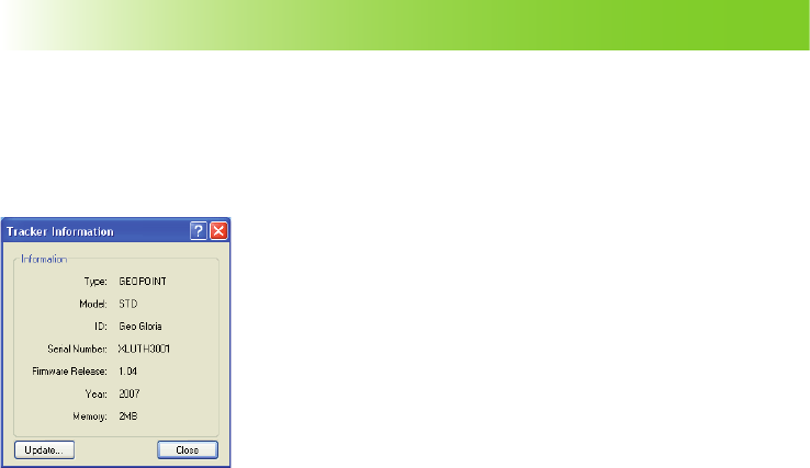
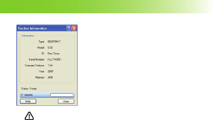
INFO
This window displays the information relevant to the connected tracker.
Information
Type Type of the connected tracker.
Model Model of the connected tracker.
ID ID assigned to the connected tracker.
Serial Number Serial number of the connected tracker.
Firmware Release Firmware release of the connected tracker.
Year Year of manufacture of the connected tracker.
Memory Memory space of the connected tracker.
Upgrade key Allows to display the tracker’s update bar.
54
MyTrack Software Structure
Update key Allows to open a window where select the
update fi le to download on the tracker.
Hide key Hides the tracker’s update bar.
Close key Exits the window.
WARNING: To update the tracker, read carefully the instructions contained in the chapter
Updates.
55
MyTrack Software Structure
Help
The Help menu allows to provide assistance for the application in use, to display the MyTrack identifi cation
data and other useful functions.
Help Provides assistance for the application.
Open www.i-scout.it Open the default PC browser and display the I-Scout home page.
Check for Upgrade Allows to check if a MyTrack upgrade is available. If a new MyTrack
version is available, a confi rm window for upgrade downloading is
displayed (function available only in case of internet connection).
About Allows to display the software version, the name of the Manufacturer and
the copyright information.
56
MyTrack Software Structure
www.cte.it
Distributed by
12

Hulp nodig? Stel uw vraag in het forum

Spelregels

Misbruik melden

Gebruikershandleiding.com neemt misbruik van zijn services uitermate serieus. U kunt hieronder aangeven waarom deze vraag ongepast is. Wij controleren de vraag en zonodig wordt deze verwijderd.

Product:

Bijvoorbeeld antisemitische inhoud, racistische inhoud, of materiaal dat gewelddadige fysieke handelingen tot gevolg kan hebben.

Bijvoorbeeld een creditcardnummer, een persoonlijk identificatienummer, of een geheim adres. E-mailadressen en volledige namen worden niet als privégegevens beschouwd.

Spelregels forum

Om tot zinvolle vragen te komen hanteren wij de volgende spelregels:

Belangrijk! Als er een antwoord wordt gegeven op uw vraag, dan is het voor de gever van het antwoord nuttig om te weten als u er wel (of niet) mee geholpen bent! Wij vragen u dus ook te reageren op een antwoord.

Belangrijk! Antwoorden worden ook per e-mail naar abonnees gestuurd. Laat uw emailadres achter op deze site, zodat u op de hoogte blijft. U krijgt dan ook andere vragen en antwoorden te zien.

Abonneren

Abonneer u voor het ontvangen van emails voor uw Midland MyTrack bij:


U ontvangt een email met instructies om u voor één of beide opties in te schrijven.


Ontvang uw handleiding per email

Vul uw emailadres in en ontvang de handleiding van Midland MyTrack in de taal/talen: Engels als bijlage per email.

De handleiding is 3,52 mb groot.


U ontvangt de handleiding per email binnen enkele minuten. Als u geen email heeft ontvangen, dan heeft u waarschijnlijk een verkeerd emailadres ingevuld of is uw mailbox te vol. Daarnaast kan het zijn dat uw internetprovider een maximum heeft aan de grootte per email. Omdat hier een handleiding wordt meegestuurd, kan het voorkomen dat de email groter is dan toegestaan bij uw provider.

Stel vragen via chat aan uw handleiding

Stel uw vraag over deze PDF

Uw handleiding is per email verstuurd. Controleer uw email

Als u niet binnen een kwartier uw email met handleiding ontvangen heeft, kan het zijn dat u een verkeerd emailadres heeft ingevuld of dat uw emailprovider een maximum grootte per email heeft ingesteld die kleiner is dan de grootte van de handleiding.

Er is een email naar u verstuurd om uw inschrijving definitief te maken.

Controleer uw email en volg de aanwijzingen op om uw inschrijving definitief te maken

U heeft geen emailadres opgegeven

Als u de handleiding per email wilt ontvangen, vul dan een geldig emailadres in.

Uw vraag is op deze pagina toegevoegd

Wilt u een email ontvangen bij een antwoord en/of nieuwe vragen? Vul dan hier uw emailadres in.


Info