Preference setting for all route calculations. This setting is recommended if you usually have the same
preference for your routes.
Calculation Method
– Allows you to control how thoroughly the StreetPilot searches for the perfect route.
A trade-off exists between the length of time the unit takes to fi nd a route and the quality of that route
(given the calculation criterion selected under Route Preference settings). The following options are avail-
able:
• Quickest Calculation: This calculation returns the fastest results, but it might not fi nd the best route.
• Quick Calculation: This takes a bit more time to calculate than the ‘Quickest Calculation’ method,
but generates a better quality route.
• Better Route: This generates an even better quality route, but uses a longer calculation time than the
‘Quick Calculation’ method.
• Best Route: This generates the most optimal route, but takes the longest time to calculate.• Best Route: This generates the most optimal route, but takes the longest time to calculate.
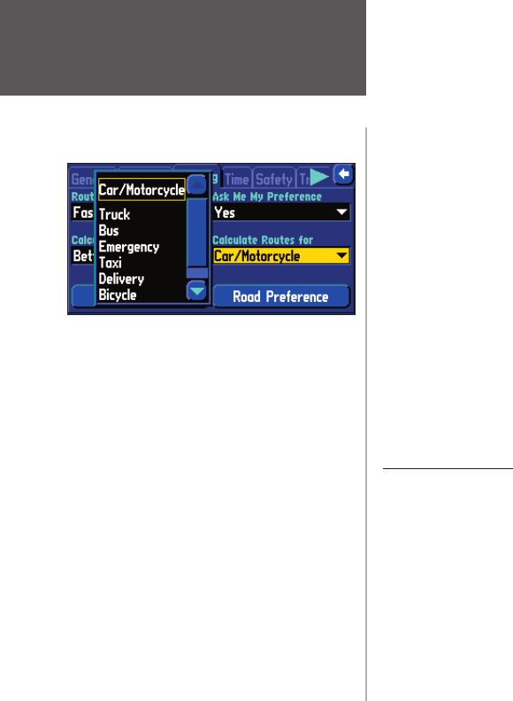
Calculate Routes forCalculate Routes for ––Allows you to take full advantage of the routing information built into the City Allows you to take full advantage of the routing information built into the City
Navigator mapping software. Some roads have vehicle-based restrictions. For example, a street or gate mayNavigator mapping software. Some roads have vehicle-based restrictions. For example, a street or gate may
be accessible by emergency vehicles only, or a residential street may not allow commercial trucking traffibe accessible by emergency vehicles only, or a residential street may not allow commercial trucking traffi c.
By specifying which vehicle type you are driving, you optimize the route for your vehicle type. Likewise,
the StreetPilot may give you access to roads or turns that wouldn’t be available to normal traffi c.
Avoidance button
The Avoidance button appears on the Routing tab and allows you to avoid certain road types that may
be undesirable on your route. The StreetPilot will use these road types only if alternative routes take you
too far out of your way or if no other road is available.
• U-Turns: If checked, the StreetPilot does not direct you to make a U-turn on non-divided highways.
• Toll Roads: If checked, the StreetPilot avoids entering toll roads.
• Highways: If checked, the StreetPilot avoids routing you along interstates and major highways.
• Unpaved Roads: If checked, the StreetPilot avoids unpaved surfaces.
Using the ‘Calculate Routes for’ option allows you
to take full advantage of the routing information
con
tained in the City Navigator mapping softwaretained in the City Navigator mapping software
for planning the most efficient route forfor planning the most effi cient route for your type of
vehicle.
The following options are available:
• Car/Motorcycle
• Truck (large semi-tractor/trailer/lorry)
• Bus
• Emergency (ambulance, fi re department, police, etc.)
• Taxi
• Delivery (delivery vehicles)
• Bicycle (avoids routing through interstates and major
Indien je via de "Find" knop naar Waypoints gaat kun je daar de waypoint met de naam Thuis verwijderen. Daarna kun je met mapsource een nieuwe waypoint (van jouw huisadres) uploaden. Óf je kunt op de StreetPilot de plaats aanwijzen waar je woont, en dan inzoomen tot op adres niveau, en dan een nieuwe waypoint maken met de naam "Thuis".
Geantwoord op 13-3-2015 om 20:14
Gebruikershandleiding.com neemt misbruik van zijn services uitermate serieus. U kunt hieronder aangeven waarom deze vraag ongepast is. Wij controleren de vraag en zonodig wordt deze verwijderd.
Product:
Spelregels forum
Om tot zinvolle vragen te komen hanteren wij de volgende spelregels:
lees eerst de handleiding door;
controleer of uw vraag al eerder door iemand anders is gesteld;
probeer uw vraag zo duidelijk mogelijk te stellen;
heeft u een probleem en al geprobeerd om dit op te lossen, vermeld dit erbij aub;
heeft u een oplossing gekregen van een bezoeker dan horen wij dat graag in dit forum;
wilt u een reactie geven op een vraag of antwoord, gebruik dan niet dit formulier maar klik op de knop 'reageer op deze vraag';
uw vraag wordt direct op de website gezet; vermijd daarom persoonlijke gegevens in te vullen;
Belangrijk! Als er een antwoord wordt gegeven op uw vraag, dan is het voor de gever van het antwoord nuttig om te weten als u er wel (of niet) mee geholpen bent! Wij vragen u dus ook te reageren op een antwoord.
Belangrijk! Antwoorden worden ook per e-mail naar abonnees gestuurd. Laat uw emailadres achter op deze site, zodat u op de hoogte blijft. U krijgt dan ook andere vragen en antwoorden te zien.
Abonneren
Abonneer u voor het ontvangen van emails voor uw Garmin streetpilot 2610 bij:
nieuwe vragen en antwoorden
nieuwe handleidingen
U ontvangt een email met instructies om u voor één of beide opties in te schrijven.
Ontvang uw handleiding per email
Vul uw emailadres in en ontvang de handleiding van Garmin streetpilot 2610 in de taal/talen: Engels als bijlage per email.
De handleiding is 2,14 mb groot.
U ontvangt de handleiding per email binnen enkele minuten. Als u geen email heeft ontvangen, dan heeft u waarschijnlijk een verkeerd emailadres ingevuld of is uw mailbox te vol. Daarnaast kan het zijn dat uw internetprovider een maximum heeft aan de grootte per email. Omdat hier een handleiding wordt meegestuurd, kan het voorkomen dat de email groter is dan toegestaan bij uw provider.
Stel vragen via chat aan uw handleiding
Stel uw vraag over deze PDF
Andere handleiding(en) van Garmin streetpilot 2610
Uw handleiding is per email verstuurd. Controleer uw email
Als u niet binnen een kwartier uw email met handleiding ontvangen heeft, kan het zijn dat u een verkeerd emailadres heeft ingevuld of dat uw emailprovider een maximum grootte per email heeft ingesteld die kleiner is dan de grootte van de handleiding.
Er is een email naar u verstuurd om uw inschrijving definitief te maken.
Controleer uw email en volg de aanwijzingen op om uw inschrijving definitief te maken
U heeft geen emailadres opgegeven
Als u de handleiding per email wilt ontvangen, vul dan een geldig emailadres in.
Uw vraag is op deze pagina toegevoegd
Wilt u een email ontvangen bij een antwoord en/of nieuwe vragen? Vul dan hier uw emailadres in.