The following types of navigational data can be displayed on the Mapping and Routing data tabs:
Address – Street address at your current location.
Elevation, Feet or Elevation, Meter – Elevation of your current location.
Heading – Current direction of travel.
Next Turn – Shows GPS status when stationary, the next intersection when driving, and driving
instructions for the next turn when navigating a route.
OdometerOdometer – Running total of distance traveled, based upon the distance between second-by-second Running total of distance traveled, based upon the distance between second-by-second
location readings, since the TripComputerwaslast reset.location readings, since the Trip Computer was last reset.
Satellite StatusSatellite Status – Indicates your StreetPilot’scurrent position fix with GPS satellites. Indicates your StreetPilot’s current position fi x with GPS satellites.
Speed – Your rate of travel, which can be displayed in miles or kilometers per hour.
Time of Day – Current time.
None – No tab will be displayed.
The Routing data tabs can use the same type of navigational data as ‘Mapping’ in addition to:
Arrival Distance – Distance to fi nal destination.
Arrival Time – Estimated time of arrival at fi nal destination.
Distance To Turn – Distance remaining to reach the next turn.
Time to Turn – Estimated time to go before reaching the next turn.
To show/hide all data tabs:
From the Map page, press MENU on the unit or remote. Select ‘Hide Tabs’ or ‘Show Tabs’ (depending
on the current setting).
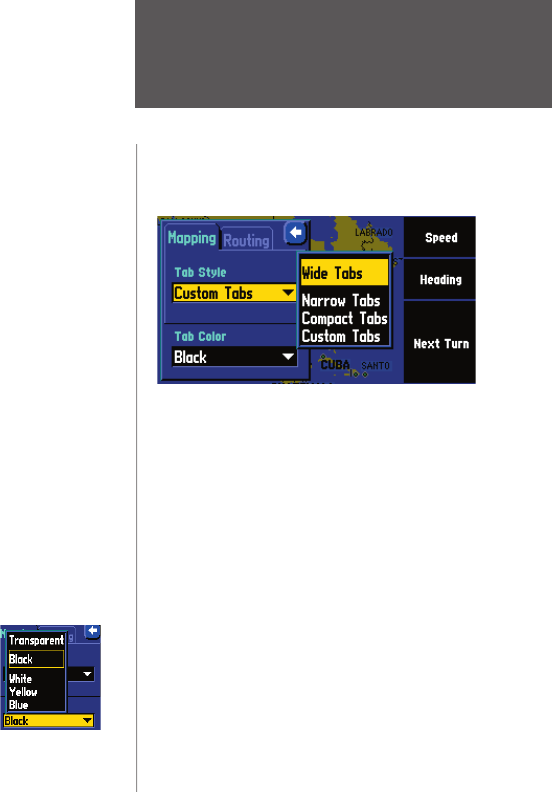
To change the data tab color:
From the ‘Tab Setup’ page, select the color box to display a list of optional tab colors.
Note that the ‘Mapping’ and ‘Routing’ tabs must be the same shade.
The Wide Tabs setting for both the Mapping and Rout-
ing tabs contain the original tab settings. Thus, if you
wish to view the original tab settings, select Wide Tabs
for both tabs.
RESTORING ORIGINAL TAB SETTINGS
Hiding/Showing Data Tabs
To show/hide one or all data tabs
using the touchscreen:
From the Map page, touch the individual tab to hide it.
The tab is replaced by a blue placeholder on the right
side of the display. Touch the placeholder to show the
tab again. A tab turns red when it is selected.
To show/hide more multiple tabs, touch and hold on the
left side of the topmost group of tabs you wish to hide,
hold and slide your fi nger in an ‘L’ shape down and right
to the side of the display. Repeat the process in reverse
Indien je via de "Find" knop naar Waypoints gaat kun je daar de waypoint met de naam Thuis verwijderen. Daarna kun je met mapsource een nieuwe waypoint (van jouw huisadres) uploaden. Óf je kunt op de StreetPilot de plaats aanwijzen waar je woont, en dan inzoomen tot op adres niveau, en dan een nieuwe waypoint maken met de naam "Thuis".
Geantwoord op 13-3-2015 om 20:14
Gebruikershandleiding.com neemt misbruik van zijn services uitermate serieus. U kunt hieronder aangeven waarom deze vraag ongepast is. Wij controleren de vraag en zonodig wordt deze verwijderd.
Product:
Spelregels forum
Om tot zinvolle vragen te komen hanteren wij de volgende spelregels:
lees eerst de handleiding door;
controleer of uw vraag al eerder door iemand anders is gesteld;
probeer uw vraag zo duidelijk mogelijk te stellen;
heeft u een probleem en al geprobeerd om dit op te lossen, vermeld dit erbij aub;
heeft u een oplossing gekregen van een bezoeker dan horen wij dat graag in dit forum;
wilt u een reactie geven op een vraag of antwoord, gebruik dan niet dit formulier maar klik op de knop 'reageer op deze vraag';
uw vraag wordt direct op de website gezet; vermijd daarom persoonlijke gegevens in te vullen;
Belangrijk! Als er een antwoord wordt gegeven op uw vraag, dan is het voor de gever van het antwoord nuttig om te weten als u er wel (of niet) mee geholpen bent! Wij vragen u dus ook te reageren op een antwoord.
Belangrijk! Antwoorden worden ook per e-mail naar abonnees gestuurd. Laat uw emailadres achter op deze site, zodat u op de hoogte blijft. U krijgt dan ook andere vragen en antwoorden te zien.
Abonneren
Abonneer u voor het ontvangen van emails voor uw Garmin streetpilot 2610 bij:
nieuwe vragen en antwoorden
nieuwe handleidingen
U ontvangt een email met instructies om u voor één of beide opties in te schrijven.
Ontvang uw handleiding per email
Vul uw emailadres in en ontvang de handleiding van Garmin streetpilot 2610 in de taal/talen: Engels als bijlage per email.
De handleiding is 2,14 mb groot.
U ontvangt de handleiding per email binnen enkele minuten. Als u geen email heeft ontvangen, dan heeft u waarschijnlijk een verkeerd emailadres ingevuld of is uw mailbox te vol. Daarnaast kan het zijn dat uw internetprovider een maximum heeft aan de grootte per email. Omdat hier een handleiding wordt meegestuurd, kan het voorkomen dat de email groter is dan toegestaan bij uw provider.
Stel vragen via chat aan uw handleiding
Stel uw vraag over deze PDF
Andere handleiding(en) van Garmin streetpilot 2610
Uw handleiding is per email verstuurd. Controleer uw email
Als u niet binnen een kwartier uw email met handleiding ontvangen heeft, kan het zijn dat u een verkeerd emailadres heeft ingevuld of dat uw emailprovider een maximum grootte per email heeft ingesteld die kleiner is dan de grootte van de handleiding.
Er is een email naar u verstuurd om uw inschrijving definitief te maken.
Controleer uw email en volg de aanwijzingen op om uw inschrijving definitief te maken
U heeft geen emailadres opgegeven
Als u de handleiding per email wilt ontvangen, vul dan een geldig emailadres in.
Uw vraag is op deze pagina toegevoegd
Wilt u een email ontvangen bij een antwoord en/of nieuwe vragen? Vul dan hier uw emailadres in.